Tax account numbers in Charles County, Maryland, page 2
1 2 3 4 5 6 7 8 9 10 11 12 13 14 15 16 17 18 19 20 21 22 23 24 25 26 27 28 29 30 31 32 33 34 35 36 37 38 39 40 41 42 43 44 45 46 47 48 49 50 51 52 53 54 55 56 57 58 59 60 61 62 63 64 65 66 67 68 69 70 71 72 73
| Address | Map, grid, parcel | Use | Assessed |
|---|---|---|---|
| #OPEN SPACE | Map 7 Grid 20 Parcel 94 · Lot OPSPI | Residential | — |
| #OPEN SPACE | Map 7 Grid 20 Parcel 94 · Lot OPSPI | Residential | — |
| #OPEN SPACE | Map 7 Grid 20 Parcel 94 · Lot OPSPJ | Residential | — |
| #OPEN SPACE | Map 7 Grid 20 Parcel 94 · Lot OPSPJ | Residential | — |
| #OPEN SPACE | Map 7 Grid 20 Parcel 94 · Lot OPSPJ | Residential | — |
| #OPEN SPACE | Map 7 Grid 20 Parcel 94 · Lot OPSPJ | Residential | — |
| #OPEN SPACE | Map 7 Grid 20 Parcel 94 · Lot OPSPJ | Residential | — |
| #OPEN SPACE | Map 7 Grid 20 Parcel 94 · Lot OPSPJ | Residential | — |
| #OPEN SPACE | Map 7 Grid 20 Parcel 94 · Lot OPSPJ | Residential | — |
| #OPEN SPACE | Map 7 Grid 20 Parcel 94 · Lot OPSPJ | Residential | — |
| #OPEN SPACE | Map 7 Grid 20 Parcel 94 · Lot OPSPJ | Residential | — |
| #OPEN SPACE | Map 7 Grid 20 Parcel 94 · Lot OPSPJ | Residential | — |
| #OPEN SPACE | Map 7 Grid 20 Parcel 94 · Lot OPSPK | Residential | — |
| #OPEN SPACE | Map 7 Grid 20 Parcel 94 · Lot OPSPK | Residential | — |
| #OPEN SPACE | Map 7 Grid 20 Parcel 94 · Lot OPSPM | Residential | — |
| #OPEN SPACE | Map 7 Grid 20 Parcel 94 · Lot OPSPO | Residential | — |
| #OPEN SPACE | Map 15 Grid 13 Parcel 36 · Lot PULTA | Residential | — |
| #OPEN SPACE | Map 7 Grid 21 Parcel 444 · Lot OPSPA | Residential | — |
| #OPEN SPACE | Map 7 Grid 21 Parcel 444 · Lot OPSPA | Residential | — |
| #OPEN SPACE | Map 7 Grid 21 Parcel 444 · Lot OPSPA | Residential | — |
| #OPEN SPACE | Map 7 Grid 21 Parcel 444 · Lot OPSPA | Residential | — |
| #OPEN SPACE | Map 7 Grid 21 Parcel 444 · Lot OPSPA | Residential | — |
| #OPEN SPACE | Map 7 Grid 21 Parcel 444 · Lot OPSPB | Residential | — |
| #OPEN SPACE | Map 7 Grid 21 Parcel 444 · Lot OPSPB | Residential | — |
| #OPEN SPACE | Map 7 Grid 21 Parcel 444 · Lot OPSPB | Residential | — |
| #OPEN SPACE | Map 7 Grid 21 Parcel 444 · Lot OPSP | Residential | — |
| #OPEN SPACE | Map 7 Grid 21 Parcel 444 · Lot OPSP | Residential | — |
| #OPEN SPACE | Map 7 Grid 21 Parcel 445 · Lot OPSPB | Residential | — |
| #OPEN SPACE | Map 8 Grid 14 Parcel 354 · Lot OPSPA | Residential | — |
| #OPEN SPACE | Map 8 Grid 14 Parcel 354 · Lot OPSPA | Residential | — |
| #OPEN SPACE | Map 8 Grid 14 Parcel 354 · Lot OPSPA | Residential | — |
| #OPEN SPACE | Map 8 Grid 14 Parcel 354 · Lot OPSPA | Residential | — |
| #OPEN SPACE | Map 8 Grid 14 Parcel 354 · Lot OPSPA | Residential | — |
| #OPEN SPACE | Map 8 Grid 14 Parcel 354 · Lot OPSPB | Residential | — |
| #OPEN SPACE | Map 8 Grid 14 Parcel 354 · Lot OPSPB | Residential | — |
| #OPEN SPACE | Map 8 Grid 14 Parcel 354 · Lot OPSPB | Residential | — |
| #OPEN SPACE | Map 8 Grid 14 Parcel 354 · Lot OPSPB | Residential | — |
| #OPEN SPACE | Map 13 Grid 6 Parcel 259 · Block N Lot OPSP | Residential | — |
| #OPEN SPACE | Map 13 Grid 6 Parcel 259 · Block N Lot OPSP | Residential | — |
| #OPEN SPACE | Map 13 Grid 6 Parcel 259 · Block O Lot OPSP | Residential | — |
| #OPEN SPACE | Map 13 Grid 6 Parcel 259 · Block O Lot OPSP | Residential | — |
| #OPEN SPACE | Map 13 Grid 6 Parcel 259 · Block O Lot OPSP | Residential | — |
| #OPEN SPACE | Map 13 Grid 6 Parcel 259 · Block O Lot OPSP | Residential | — |
| #OPEN SPACE | Map 7 Grid 23 Parcel 446 · Lot OPSP | Residential | — |
| #OPEN SPACE | Map 7 Grid 23 Parcel 446 · Lot OPSP | Residential | — |
| #OPEN SPACE | Map 7 Grid 23 Parcel 446 · Lot OPSP | Residential | — |
| #OPEN SPACE | Map 24 Grid 3 Parcel 149 · Lot OPSPA | Residential | — |
| #OPEN SPACE | Map 24 Grid 3 Parcel 149 · Lot OPSPB | Residential | — |
| #OPEN SPACE | Map 24 Grid 3 Parcel 149 · Lot OPSPC | Residential | — |
| #OPEN SPACE | Map 24 Grid 3 Parcel 149 · Lot OPSPD | Residential | — |
| #OPEN SPACE | Map 24 Grid 3 Parcel 149 · Lot OPSPE | Residential | — |
| #OPEN SPACE | Map 24 Grid 3 Parcel 149 · Lot OPSPF | Residential | — |
| #OPEN SPACE | Map 24 Grid 3 Parcel 149 · Lot OPSPG | Residential | — |
| #OPEN SPACE | Map 24 Grid 3 Parcel 149 · Lot OPSPH | Residential | — |
| #OPEN SPACE | Map 24 Grid 3 Parcel 149 · Lot OPSPI | Residential | — |
| #OPEN SPACE | Map 24 Grid 3 Parcel 149 · Lot OPSPJ | Residential | — |
| #OPEN SPACE | Map 14 Grid 10 Parcel 167 · Lot OPSPA | Residential | — |
| #OPEN SPACE | Map 14 Grid 10 Parcel 167 · Lot OPSPB | Residential | — |
| #OPEN SPACE | Map 14 Grid 10 Parcel 167 · Lot OPSPC | Residential | — |
| #OPEN SPACE | Map 14 Grid 10 Parcel 167 · Lot OPSPD | Residential | — |
| #OPEN SPACE | Map 14 Grid 6 Parcel 339 · Lot OPSPA | Residential | — |
| #OPEN SPACE | Map 14 Grid 6 Parcel 339 · Lot OPSPA | Residential | — |
| #OPEN SPACE | Map 14 Grid 6 Parcel 339 · Lot OPSPA | Residential | — |
| #OPEN SPACE | Map 14 Grid 6 Parcel 339 · Lot OPSPA | Residential | — |
| #OPEN SPACE | Map 14 Grid 6 Parcel 339 · Lot OPSPA | Residential | — |
| #OPEN SPACE | Map 14 Grid 6 Parcel 339 · Lot OPSPB | Residential | — |
| #OPEN SPACE | Map 14 Grid 6 Parcel 339 · Lot OPSPB | Residential | — |
| #OPEN SPACE | Map 14 Grid 6 Parcel 339 · Lot OPSPC | Residential | — |
| #OPEN SPACE | Map 14 Grid 6 Parcel 339 · Lot OPSAC | Residential | — |
| #OPEN SPACE | Map 14 Grid 6 Parcel 339 · Lot OPSPC | Residential | — |
| #OPEN SPACE | Map 14 Grid 6 Parcel 339 · Lot OPSPD | Residential | — |
| #OPEN SPACE | Map 14 Grid 6 Parcel 339 · Lot OPSPE | Residential | — |
| #OPEN SPACE | Map 14 Grid 6 Parcel 339 · Lot OPSPE | Residential | — |
| #OPEN SPACE | Map 14 Grid 6 Parcel 339 · Lot OPSPE | Residential | — |
| #OPEN SPACE | Map 23 Grid 1 Parcel 276 · Lot OPSPB | Residential | — |
| #OPEN SPACE | Map 23 Grid 1 Parcel 276 · Lot OPSPC | Residential | — |
| #OPEN SPACE | Map 7 Grid 17 Parcel 443 · Lot OP SP | Residential | — |
| #OPEN SPACE | Map 7 Grid 17 Parcel 443 · Lot OP SP | Residential | — |
| #OPEN SPACE | Map 7 Grid 17 Parcel 443 · Lot OP SP | Residential | — |
| #OPEN SPACE | Map 7 Grid 17 Parcel 443 · Lot OP SP | Residential | — |
| #OPEN SPACE | Map 7 Grid 17 Parcel 443 · Lot OP SP | Residential | — |
| #OPEN SPACE | Map 7 Grid 17 Parcel 443 · Lot OP SP | Residential | — |
| #OPEN SPACE | Map 7 Grid 17 Parcel 443 · Lot OP SP | Residential | — |
| #OPEN SPACE | Map 7 Grid 17 Parcel 443 · Lot OP SP | Residential | — |
| #OPEN SPACE | Map 7 Grid 17 Parcel 443 · Lot OP SP | Residential | — |
| #OPEN SPACE | Map 7 Grid 17 Parcel 443 · Lot OP SP | Residential | — |
| #OPEN SPACE | Map 7 Grid 21 Parcel 441 · Lot OP SP | Residential | — |
| #OPEN SPACE | Map 7 Grid 21 Parcel 441 · Lot OP SP | Residential | — |
| #OPEN SPACE | Map 7 Grid 21 Parcel 441 · Lot OP SP | Residential | — |
| #OPEN SPACE | Map 13 Grid 6 Parcel 260 · Lot OP SP | Residential | — |
| #OPEN SPACE | Map 13 Grid 6 Parcel 260 · Lot OP SP | Residential | — |
| #OPEN SPACE | Map 13 Grid 6 Parcel 260 · Lot OP SP | Residential | — |
| #OPEN SPACE | Map 13 Grid 6 Parcel 260 · Lot OP SP | Residential | — |
| #OPEN SPACE | Map 13 Grid 6 Parcel 260 · Lot OP SP | Residential | — |
| #OPEN SPACE | Map 13 Grid 6 Parcel 260 · Lot OP SP | Residential | — |
| #OPEN SPACE | Map 7 Grid 21 Parcel 447 | Residential | — |
| #OPEN SPACE | Map 7 Grid 21 Parcel 447 | Residential | — |
| #OPEN SPACE | Map 7 Grid 21 Parcel 447 | Residential | — |
| #OPEN SPACE | Map 7 Grid 21 Parcel 447 | Residential | — |
| #OPEN SPACE | Map 24 Grid 9 Parcel 150 · Lot OP SP | Residential | — |
| #OPEN SPACE | Map 24 Grid 9 Parcel 150 · Lot OP SP | Residential | — |
| #OPEN SPACE | Map 24 Grid 9 Parcel 150 · Lot OP SP | Residential | — |
| #OPEN SPACE | Map 24 Grid 9 Parcel 150 · Lot OP SP | Residential | — |
| #OPEN SPACE | Map 24 Grid 9 Parcel 150 · Lot OP SP | Residential | — |
| #OPEN SPACE | Map 24 Grid 9 Parcel 150 · Lot OP SP | Residential | — |
| #OPEN SPACE | Map 24 Grid 9 Parcel 150 · Lot OP SP | Residential | — |
| #OPEN SPACE | Map 24 Grid 9 Parcel 150 · Lot OP SP | Residential | — |
| #OPEN SPACE | Map 24 Grid 9 Parcel 150 · Lot OP SP | Residential | — |
| #OPEN SPACE | Map 24 Grid 9 Parcel 150 · Lot OP SP | Residential | — |
| #OPEN SPACE | Map 24 Grid 9 Parcel 150 · Lot OP SP | Residential | — |
| #OPEN SPACE | Map 24 Grid 9 Parcel 150 · Lot OP SP | Residential | — |
| #OPEN SPACE | Map 14 Grid 10 Parcel 164 · Lot OPSPA | Residential | — |
| #OPEN SPACE | Map 14 Grid 10 Parcel 164 · Lot OPSPD | Residential | — |
| #OPEN SPACE | Map 14 Grid 10 Parcel 164 · Lot OPSPE | Residential | — |
| #OPEN SPACE | Map 14 Grid 10 Parcel 164 · Lot OPSPF | Residential | — |
| #OPEN SPACE | Map 14 Grid 10 Parcel 164 · Lot OPSPG | Residential | — |
| #OPEN SPACE | Map 15 Grid 5 Parcel 324 · Lot OPSPA | Residential | — |
| #OPEN SPACE | Map 15 Grid 5 Parcel 324 · Lot OPSPB | Residential | — |
| #OPEN SPACE | Map 15 Grid 5 Parcel 324 · Lot OPSPE | Residential | — |
| #OPEN SPACE | Map 24 Grid 8 Parcel 152 · Lot OPSPA | Residential | — |
| #OPEN SPACE | Map 24 Grid 8 Parcel 152 · Lot OPSPB | Residential | — |
| #OPEN SPACE | Map 24 Grid 8 Parcel 152 · Lot OPSPC | Residential | — |
| #OPEN SPACE | Map 24 Grid 8 Parcel 152 · Lot OPSPD | Residential | — |
| #OPEN SPACE | Map 24 Grid 8 Parcel 152 · Lot OPSPE | Residential | — |
| #OPEN SPACE | Map 24 Grid 8 Parcel 152 · Lot OPSPF | Residential | — |
| #OPEN SPACE | Map 24 Grid 8 Parcel 152 · Lot OPSPG | Residential | — |
| #OPEN SPACE | Map 24 Grid 8 Parcel 152 · Lot OPSPH | Residential | — |
| #OPEN SPACE | Map 24 Grid 8 Parcel 152 · Lot OPSPI | Residential | — |
| #OPEN SPACE | Map 24 Grid 8 Parcel 152 · Lot OPSPJ | Residential | — |
| #OPEN SPACE | Map 24 Grid 8 Parcel 152 · Lot OPSPK | Residential | — |
| #OPEN SPACE | Map 24 Grid 8 Parcel 152 · Lot OPSPL | Residential | — |
| #OPEN SPACE | Map 24 Grid 8 Parcel 152 · Lot OPSPM | Residential | — |
| #OPEN SPACE | Map 14 Grid 1 Parcel 27 · Lot OPSPA | Residential | — |
| #OPEN SPACE | Map 14 Grid 1 Parcel 27 · Lot OPSPA | Residential | — |
| #OPEN SPACE | Map 14 Grid 1 Parcel 27 · Lot OPSPB | Residential | — |
| #OPEN SPACE | Map 14 Grid 1 Parcel 27 · Lot OPSPC | Residential | — |
| #OPEN SPACE | Map 14 Grid 1 Parcel 27 · Lot OPSPD | Residential | — |
| #OPEN SPACE | Map 14 Grid 1 Parcel 27 · Lot OPSPF | Residential | — |
| #OPEN SPACE | Map 14 Grid 1 Parcel 27 · Lot OPSPD | Residential | — |
| #OPEN SPACE | Map 13 Grid 2 Parcel 262 · Lot OPSPA | Residential | — |
| #OPEN SPACE | Map 13 Grid 2 Parcel 262 · Lot OPSPB | Residential | — |
| #OPEN SPACE | Map 13 Grid 2 Parcel 262 · Lot OPSPC | Residential | — |
| #OPEN SPACE | Map 24 Grid 3 Parcel 115 · Lot OPSPA | Town House | — |
| #OPEN SPACE | Map 7 Grid 17 Parcel 451 · Lot OPSPH | Residential | — |
| #OPEN SPACE | Map 24 Grid 3 Parcel 115 · Lot OPSPB | Town House | — |
| #OPEN SPACE | Map 7 Grid 17 Parcel 451 · Lot OPSPH | Residential | — |
| #OPEN SPACE | Map 7 Grid 17 Parcel 451 · Lot OPSPH | Residential | — |
| #OPEN SPACE | Map 24 Grid 3 Parcel 115 · Lot OPSPC | Town House | — |
| #OPEN SPACE | Map 7 Grid 17 Parcel 451 · Lot OPSPG | Residential | — |
| #OPEN SPACE | Map 24 Grid 3 Parcel 115 · Lot OPSPD | Town House | — |
| #OPEN SPACE | Map 7 Grid 17 Parcel 451 · Lot OPSPG | Residential | — |
| #OPEN SPACE | Map 24 Grid 3 Parcel 115 · Lot OPSPE | Town House | — |
| #OPEN SPACE | Map 7 Grid 17 Parcel 451 · Lot OPSPG | Residential | — |
| #OPEN SPACE | Map 7 Grid 17 Parcel 451 · Lot OPSPG | Residential | — |
| #OPEN SPACE | Map 7 Grid 17 Parcel 451 · Lot OPSPL | Residential | — |
| #OPEN SPACE | Map 7 Grid 17 Parcel 451 · Lot OPSPL | Residential | — |
| #OPEN SPACE | Map 7 Grid 17 Parcel 451 · Lot OPSPM | Residential | — |
| #OPEN SPACE | Map 24 Grid 3 Parcel 115 · Lot OPSPF | Town House | — |
| #OPEN SPACE | Map 24 Grid 3 Parcel 115 · Lot OPSPG | Town House | — |
| #OPEN SPACE | Map 24 Grid 3 Parcel 115 · Lot OPSPH | Town House | — |
| #OPEN SPACE | Map 24 Grid 3 Parcel 115 · Lot OPSPI | Town House | — |
| #OPEN SPACE | Map 24 Grid 3 Parcel 115 · Lot OPSPJ | Town House | — |
| #OPEN SPACE | Map 24 Grid 3 Parcel 115 · Lot OPSPK | Town House | — |
| #OPEN SPACE | Map 24 Grid 3 Parcel 115 · Lot OPSPL | Town House | — |
| #OPEN SPACE | Map 24 Grid 3 Parcel 115 · Lot OPSPM | Town House | — |
| #OPEN SPACE | Map 24 Grid 3 Parcel 115 · Lot OPSPN | Town House | — |
| #OPEN SPACE | Map 24 Grid 3 Parcel 115 · Lot OPSPO | Town House | — |
| #OPEN SPACE | Map 24 Grid 3 Parcel 115 · Lot OPSPP | Town House | — |
| #OPEN SPACE | Map 24 Grid 3 Parcel 115 · Lot OPSPR | Town House | — |
| #OPEN SPACE | Map 24 Grid 3 Parcel 115 · Lot OPSPS | Residential | — |
| #OPEN SPACE | Map 7 Grid 13 Parcel 452 · Lot OPSPE | Residential | — |
| #OPEN SPACE | Map 7 Grid 13 Parcel 452 · Lot OPSPE | Residential | — |
| #OPEN SPACE | Map 7 Grid 13 Parcel 452 · Lot OPSPB | Residential | — |
| #OPEN SPACE | Map 7 Grid 13 Parcel 452 · Lot OPSPB | Residential | — |
| #OPEN SPACE | Map 7 Grid 13 Parcel 452 · Lot OPSPF | Residential | — |
| #OPEN SPACE | Map 7 Grid 13 Parcel 452 · Lot OPSPA | Residential | — |
| #OPEN SPACE | Map 7 Grid 22 Parcel 64 · Lot OPSPB | Residential | — |
| #OPEN SPACE | Map 7 Grid 22 Parcel 64 · Lot PAR 3 | Residential | — |
| #OPEN SPACE | Map 7 Grid 22 Parcel 64 · Lot PAR 4 | Residential | — |
| #OPEN SPACE | Map 24 Grid 4 Parcel 129 · Lot OPSP | Residential | — |
| #OPEN SPACE | Map 23 Grid 1 Parcel 19 · Lot LOT A | Residential | $100 |
| #OPEN SPACE | Map 7 Grid 21 Parcel 158 · Lot OPSPE | Residential | — |
| #OPEN SPACE | Map 24 Grid 3 Parcel 129 · Lot OPSP | Residential | — |
| #OPEN SPACE | Map 24 Grid 15 Parcel 156 · Lot OPSP | Residential | — |
| #OPEN SPACE | Map 24 Grid 15 Parcel 156 · Lot OPSP | Residential | — |
| #OPEN SPACE | Map 24 Grid 15 Parcel 156 · Lot OPSP | Residential | — |
| #OPEN SPACE | Map 24 Grid 15 Parcel 156 · Lot OPSP | Residential | — |
| #OPEN SPACE | Map 24 Grid 15 Parcel 156 · Lot OPSP | Residential | — |
| #OPEN SPACE | Map 24 Grid 15 Parcel 156 · Lot OPSP | Residential | — |
| #OPEN SPACE | Map 24 Grid 15 Parcel 156 · Lot OPSP | Residential | — |
| #OPEN SPACE | Map 24 Grid 15 Parcel 156 · Lot OPSP | Residential | — |
| #OPEN SPACE | Map 24 Grid 15 Parcel 156 · Lot OPSP | Residential | — |
| #OPEN SPACE | Map 24 Grid 15 Parcel 156 · Lot OPSP | Residential | — |
| #OPEN SPACE | Map 24 Grid 15 Parcel 156 · Lot OPSP | Residential | — |
| #OPEN SPACE | Map 24 Grid 15 Parcel 156 · Lot OPSP | Residential | — |
| #OPEN SPACE | Map 24 Grid 15 Parcel 156 · Lot OPSP | Residential | — |
| #OPEN SPACE | Map 24 Grid 15 Parcel 156 · Lot OPSP | Residential | — |
| #OPEN SPACE | Map 14 Grid 1 Parcel 27 · Lot OP SP | Residential | — |
| #OPEN SPACE | Map 14 Grid 1 Parcel 27 · Lot OP SP | Residential | — |
| #OPEN SPACE | Map 14 Grid 1 Parcel 27 · Lot OP SP | Residential | — |
| #OPEN SPACE | Map 14 Grid 1 Parcel 27 · Lot OP SP | Residential | — |
| #OPEN SPACE | Map 14 Grid 1 Parcel 27 · Lot OP SP | Residential | — |
| #OPEN SPACE | Map 14 Grid 1 Parcel 27 · Lot OP SP | Residential | — |
| #OPEN SPACE | Map 14 Grid 1 Parcel 27 · Lot OP SP | Residential | — |
| #OPEN SPACE | Map 7 Grid 23 Parcel 453 · Lot OP SP | Residential | — |
| #OPEN SPACE | Map 7 Grid 23 Parcel 453 · Lot OP SP | Residential | — |
| #OPEN SPACE | Map 7 Grid 23 Parcel 453 · Lot OPSPC | Residential | — |
| #OPEN SPACE | Map 7 Grid 3 Parcel 312 · Lot PAR A | Residential | — |
| #OPEN SPACE | Map 7 Grid 3 Parcel 312 · Lot OP SP | Residential | — |
| #OPEN SPACE | Map 7 Grid 3 Parcel 312 · Lot OP SP | Residential | — |
| #OPEN SPACE | Map 24 Grid 9 Parcel 161 | Residential | — |
| #OPEN SPACE | Map 24 Grid 9 Parcel 161 | Residential | — |
| #OPEN SPACE | Map 24 Grid 9 Parcel 161 | Residential | — |
| #OPEN SPACE | Map 24 Grid 9 Parcel 161 | Residential | — |
| #OPEN SPACE | Map 24 Grid 9 Parcel 161 | Residential | — |
| #OPEN SPACE | Map 15 Grid 5 Parcel 197 | Residential | — |
| #OPEN SPACE | Map 15 Grid 5 Parcel 197 | Residential | — |
| #OPEN SPACE | Map 15 Grid 5 Parcel 197 | Residential | — |
| #OPEN SPACE | Map 15 Grid 5 Parcel 197 | Residential | — |
| #OPEN SPACE | Map 14 Grid 18 Parcel 227 · Lot OP A | Residential | — |
| #OPEN SPACE | Map 14 Grid 18 Parcel 227 · Lot OP A | Residential | — |
| #OPEN SPACE | Map 13 Grid 2 Parcel 6 | Residential | — |
| #OPEN SPACE | Map 14 Grid 1 Parcel 27 | Residential | — |
| #OPEN SPACE | Map 14 Grid 1 Parcel 27 | Residential | — |
| #OPEN SPACE | Map 14 Grid 1 Parcel 27 | Residential | — |
| #OPEN SPACE | Map 7 Grid 13 Parcel 31 | Residential | — |
| #OPEN SPACE | Map 7 Grid 13 Parcel 31 | Residential | — |
| #OPEN SPACE | Map 7 Grid 13 Parcel 31 | Residential | — |
| #OPEN SPACE | Map 7 Grid 13 Parcel 31 | Residential | — |
| #OPEN SPACE | Map 7 Grid 13 Parcel 31 | Residential | — |
| #OPEN SPACE | Map 24 Grid 9 Parcel 163 · Lot OPSP2 | Residential | — |
| #OPEN SPACE | Map 24 Grid 9 Parcel 163 | Residential | — |
| #OPEN SPACE | Map 24 Grid 9 Parcel 163 | Residential | — |
| #OPEN SPACE | Map 24 Grid 9 Parcel 163 | Residential | — |
| #OPEN SPACE | Map 24 Grid 9 Parcel 163 | Residential | — |
| #OPEN SPACE | Map 24 Grid 9 Parcel 163 | Residential | — |
| #OPEN SPACE | Map 24 Grid 9 Parcel 163 | Residential | — |
| #OPEN SPACE | Map 24 Grid 9 Parcel 163 | Residential | — |
| #OPEN SPACE | Map 24 Grid 9 Parcel 163 | Residential | — |
| #OPEN SPACE | Map 24 Grid 9 Parcel 163 | Residential | — |
| #OPEN SPACE | Map 24 Grid 9 Parcel 163 | Residential | — |
| #OPEN SPACE | Map 7 Grid 21 Parcel 442 · Lot OS A | Residential | — |
| #OPEN SPACE | Map 7 Grid 21 Parcel 442 · Lot OS A | Residential | — |
| #OPEN SPACE | Map 7 Grid 21 Parcel 442 | Residential | — |
| #OPEN SPACE | Map 7 Grid 21 Parcel 442 | Residential | — |
| #OPEN SPACE | Map 7 Grid 21 Parcel 442 | Residential | — |
| #OPEN SPACE | Map 14 Grid 1 Parcel 27 | Residential | — |
| #OPEN SPACE | Map 14 Grid 1 Parcel 27 | Residential | — |
| #OPEN SPACE | Map 24 Grid 14 Parcel 149 · Lot OPSP | Residential | — |
| #OPEN SPACE | Map 24 Grid 14 Parcel 149 · Lot OPSP | Residential | — |
| #OPEN SPACE | Map 24 Grid 14 Parcel 149 · Lot OPSP | Residential | — |
| #OPEN SPACE | Map 24 Grid 14 Parcel 149 · Lot OPSP | Residential | — |
| #OPEN SPACE | Map 24 Grid 14 Parcel 149 · Lot OPSP | Residential | — |
| #OPEN SPACE | Map 24 Grid 14 Parcel 149 · Lot OPSP | Residential | — |
| #OPEN SPACE | Map 24 Grid 14 Parcel 149 · Lot OPSP | Residential | — |
| #OPEN SPACE | Map 24 Grid 14 Parcel 149 · Lot OPSP | Residential | — |
| #OPEN SPACE | Map 24 Grid 14 Parcel 149 · Lot OPSP | Residential | — |
| #OPEN SPACE | Map 24 Grid 14 Parcel 149 · Lot OPSP | Residential | — |
| #OPEN SPACE | Map 24 Grid 14 Parcel 149 · Lot OPSP | Residential | — |
| #OPEN SPACE | Map 24 Grid 14 Parcel 149 · Lot OPSP | Residential | — |
| #OPEN SPACE | Map 24 Grid 14 Parcel 149 · Lot OPSP | Residential | — |
| #OPEN SPACE | Map 24 Grid 14 Parcel 149 · Lot OPSP | Residential | — |
| #OPEN SPACE | Map 24 Grid 14 Parcel 149 · Lot OPSP | Residential | — |
| #OPEN SPACE | Map 24 Grid 14 Parcel 149 · Lot OPSP | Residential | — |
| #OPEN SPACE | Map 15 Grid 5 Parcel 324 | Residential | — |
| #OPEN SPACE | Map 15 Grid 5 Parcel 324 | Residential | — |
| #OPEN SPACE | Map 15 Grid 5 Parcel 324 | Residential | — |
| #OPEN SPACE | Map 15 Grid 5 Parcel 324 | Residential | — |
| #OPEN SPACE | Map 15 Grid 5 Parcel 324 | Residential | — |
| #OPEN SPACE | Map 13 Grid 5 Parcel 324 | Residential | — |
| #OPEN SPACE | Map 15 Grid 5 Parcel 324 | Residential | — |
| #OPEN SPACE | Map 15 Grid 5 Parcel 324 | Residential | — |
| #OPEN SPACE | Map 15 Grid 5 Parcel 324 | Residential | — |
| #OPEN SPACE | Map 8 Grid 5 Parcel 133 | Residential | — |
| #OPEN SPACE | Map 7 Grid 17 Parcel 27 | Residential | — |
| #OPEN SPACE | Map 7 Grid 17 Parcel 27 | Residential | — |
| #OPEN SPACE | Map 7 Grid 17 Parcel 27 | Residential | — |
| #OPEN SPACE | Map 7 Grid 17 Parcel 27 | Residential | — |
| #OPEN SPACE | Map 7 Grid 23 Parcel 166 | Residential | — |
| #OPEN SPACE | Map 7 Grid 23 Parcel 166 | Residential | — |
| #OPEN SPACE | Map 7 Grid 21 Parcel 442 | Residential | — |
| #OPEN SPACE | Map 7 Grid 21 Parcel 442 · Lot OS A | Residential | — |
| #OPEN SPACE | Map 7 Grid 21 Parcel 442 | Residential | — |
| #OPEN SPACE | Map 7 Grid 13 Parcel 31 | Residential | — |
| #OPEN SPACE | Map 7 Grid 13 Parcel 31 | Residential | — |
| #OPEN SPACE | Map 7 Grid 13 Parcel 31 | Residential | — |
| #OPEN SPACE | Map 7 Grid 13 Parcel 31 | Residential | — |
| #OPEN SPACE | Map 7 Grid 13 Parcel 31 | Residential | — |
| #OPEN SPACE | Map 7 Grid 13 Parcel 31 | Residential | — |
| #OPEN SPACE | Map 7 Grid 13 Parcel 31 | Residential | — |
| #OPEN SPACE | Map 7 Grid 13 Parcel 31 | Residential | — |
| #OPEN SPACE | Map 14 Grid 1 Parcel 267 | Residential | — |
| #OPEN SPACE | Map 14 Grid 1 Parcel 267 | Residential | — |
| #OPEN SPACE | Map 7 Grid 3 Parcel 221 | Residential | — |
| #OPEN SPACE | Map 7 Grid 3 Parcel 221 | Residential | — |
| #OPEN SPACE | Map 7 Grid 3 Parcel 221 | Residential | — |
| #OPEN SPACE | Map 7 Grid 3 Parcel 221 | Residential | — |
| #OPEN SPACE | Map 7 Grid 3 Parcel 221 | Residential | — |
| #OPEN SPACE | Map 7 Grid 3 Parcel 221 | Residential | — |
| #OPEN SPACE | Map 7 Grid 3 Parcel 221 | Residential | — |
| #OPEN SPACE | Map 7 Grid 3 Parcel 221 | Residential | — |
| #OPEN SPACE | Map 7 Grid 3 Parcel 221 | Residential | — |
| #OPEN SPACE | Map 7 Grid 3 Parcel 221 | Residential | — |
| #OPEN SPACE | Map 7 Grid 3 Parcel 221 | Residential | — |
| #OPEN SPACE | Map 7 Grid 3 Parcel 221 | Residential | — |
| #OPEN SPACE | Map 7 Grid 3 Parcel 221 | Residential | — |
| #OPEN SPACE | Map 7 Grid 3 Parcel 221 | Residential | — |
| #OPEN SPACE | Map 24 Grid 8 Parcel 117 · Lot OPSPA | Residential | — |
| #OPEN SPACE | Map 24 Grid 8 Parcel 117 · Lot OPSPB | Residential | — |
| #OPEN SPACE | Map 24 Grid 8 Parcel 117 · Lot OPSPC | Residential | — |
| #OPEN SPACE | Map 24 Grid 8 Parcel 117 · Lot OPSPD | Residential | — |
| #OPEN SPACE | Map 24 Grid 8 Parcel 117 · Lot OPSPF | Residential | — |
| #OPEN SPACE | Map 24 Grid 8 Parcel 117 · Lot OPSPG | Residential | — |
| #OPEN SPACE | Map 24 Grid 8 Parcel 117 · Lot OPSPH | Residential | — |
| #OPEN SPACE | Map 24 Grid 8 Parcel 117 · Lot OPSPI | Residential | — |
| #OPEN SPACE | Map 24 Grid 8 Parcel 117 · Lot OPSPJ | Residential | — |
| #OPEN SPACE | Map 24 Grid 9 Parcel 87 · Lot OPSPE | Commercial | — |
| #OPEN SPACE | Map 15 Grid 5 Parcel 324 | Residential | — |
| #OPEN SPACE | Map 15 Grid 5 Parcel 324 | Residential | — |
| #OPEN SPACE | Map 15 Grid 5 Parcel 324 | Residential | — |
| #OPEN SPACE | Map 15 Grid 5 Parcel 324 | Residential | — |
| #OPEN SPACE | Map 7 Grid 13 Parcel 31 | Residential | — |
| #OPEN SPACE | Map 13 Grid 2 Parcel 6 | Residential | — |
| #OPEN SPACE | Map 13 Grid 2 Parcel 6 | Residential | — |
| #OPEN SPACE | Map 13 Grid 2 Parcel 6 | Residential | — |
| #OPEN SPACE | Map 13 Grid 2 Parcel 6 | Residential | — |
| #OPEN SPACE | Map 14 Grid 12 Parcel 252 | Town House | — |
| #OPEN SPACE | Map 14 Grid 12 Parcel 252 | Town House | — |
| #OPEN SPACE | Map 14 Grid 12 Parcel 252 | Town House | — |
| #OPEN SPACE | Map 14 Grid 12 Parcel 252 | Town House | — |
| #OPEN SPACE | Map 14 Grid 12 Parcel 252 | Town House | — |
| #OPEN SPACE | Map 14 Grid 12 Parcel 252 | Town House | — |
| #OPEN SPACE | Map 14 Grid 12 Parcel 252 | Town House | — |
| #OPEN SPACE | Map 14 Grid 12 Parcel 252 | Town House | — |
| #OPEN SPACE | Map 7 Grid 23 Parcel 215 | Residential | — |
| #OPEN SPACE | Map 7 Grid 17 Parcel 27 | Residential | — |
| #OPEN SPACE | Map 7 Grid 17 Parcel 27 | Residential | — |
| #OPEN SPACE | Map 7 Grid 17 Parcel 27 | Residential | — |
| #OPEN SPACE | Map 7 Grid 17 Parcel 27 | Residential | — |
| #OPEN SPACE | Map 7 Grid 17 Parcel 27 | Residential | — |
| #OPEN SPACE | Map 7 Grid 21 Parcel 442 · Lot OS E | Residential | — |
| #OPEN SPACE | Map 7 Grid 21 Parcel 442 · Lot OS F | Residential | — |
| #OPEN SPACE | Map 7 Grid 21 Parcel 442 · Lot OS G | Residential | — |
| #OPEN SPACE | Map 14 Grid 1 Parcel 27 | Residential | — |
| #OPEN SPACE | Map 14 Grid 1 Parcel 27 | Residential | — |
| #OPEN SPACE | Map 14 Grid 7 Parcel 356 | Residential | — |
| #OPEN SPACE | Map 24 Grid 9 Parcel 87 | Residential | — |
| #OPEN SPACE | Map 8 Grid 1 Parcel 501 · Lot OPSP | Commercial | — |
| #OPEN SPACE | Map 8 Grid 1 Parcel 501 · Lot OPSP | Commercial | — |
| #OPEN SPACE | Map 7 Grid 23 Parcel 215 · Block F Lot 4 | Residential | — |
| #OPEN SPACE | Map 14 Grid 12 Parcel 252 | Town House | — |
| #OPEN SPACE | Map 14 Grid 12 Parcel 252 | Town House | — |
| #OPEN SPACE | Map 14 Grid 12 Parcel 252 | Town House | — |
| #OPEN SPACE | Map 14 Grid 12 Parcel 252 | Town House | — |
| #OPEN SPACE | Map 14 Grid 12 Parcel 252 | Town House | — |
| #OPEN SPACE | Map 14 Grid 12 Parcel 252 | Town House | — |
| #OPEN SPACE | Map 14 Grid 12 Parcel 252 | Town House | — |
| #OPEN SPACE | Map 14 Grid 12 Parcel 252 | Town House | — |
| #OPEN SPACE | Map 14 Grid 12 Parcel 252 | Town House | — |
| #OPEN SPACE | Map 14 Grid 12 Parcel 252 | Town House | — |
| #OPEN SPACE | Map 14 Grid 12 Parcel 252 | Town House | — |
| #OPEN SPACE | Map 14 Grid 12 Parcel 252 | Town House | — |
| #OPEN SPACE | Map 13 Grid 4 Parcel 177 | Residential | — |
| #OPEN SPACE | Map 13 Grid 4 Parcel 177 | Residential | — |
| #OPEN SPACE | Map 7 Grid 23 Parcel 233 | Residential | — |
| #OPEN SPACE | Map 7 Grid 23 Parcel 233 | Residential | — |
| #OPEN SPACE | Map 7 Grid 23 Parcel 233 | Residential | — |
| #OPEN SPACE | Map 7 Grid 23 Parcel 233 | Residential | — |
| #OPEN SPACE | Map 8 Grid 15 Parcel 441 | Residential | — |
| #OPEN SPACE | Map 8 Grid 15 Parcel 441 | Residential | — |
| #OPEN SPACE | Map 8 Grid 15 Parcel 441 | Residential | — |
| #OPEN SPACE | Map 8 Grid 15 Parcel 441 | Residential | — |
| #OPEN SPACE | Map 8 Grid 15 Parcel 441 | Residential | — |
| #OPEN SPACE | Map 8 Grid 15 Parcel 441 | Residential | — |
| #OPEN SPACE | Map 8 Grid 15 Parcel 441 | Residential | — |
| #OPEN SPACE | Map 8 Grid 15 Parcel 441 | Residential | — |
| #OPEN SPACE | Map 8 Grid 15 Parcel 441 | Residential | — |
| #OPEN SPACE | Map 8 Grid 15 Parcel 441 | Residential | — |
| #OPEN SPACE | Map 8 Grid 15 Parcel 441 | Residential | — |
| #OPEN SPACE | Map 8 Grid 15 Parcel 441 | Residential | — |
| #OPEN SPACE | Map 8 Grid 15 Parcel 441 | Residential | — |
| #OPEN SPACE | Map 8 Grid 15 Parcel 441 | Residential | — |
| #OPEN SPACE | Map 8 Grid 15 Parcel 441 | Residential | — |
| #OPEN SPACE | Map 7 Grid 2 Parcel 40 | Residential | — |
| #OPEN SPACE | Map 7 Grid 2 Parcel 40 | Residential | — |
| #OPEN SPACE | Map 7 Grid 2 Parcel 40 | Residential | — |
| #OPEN SPACE | Map 7 Grid 2 Parcel 40 | Residential | — |
| #OPEN SPACE | Map 7 Grid 2 Parcel 40 | Residential | — |
| #OPEN SPACE | Map 7 Grid 2 Parcel 40 | Residential | — |
| #OPEN SPACE | Map 7 Grid 2 Parcel 40 | Residential | — |
| #OPEN SPACE | Map 7 Grid 2 Parcel 40 | Residential | — |
| #OPEN SPACE | Map 7 Grid 2 Parcel 40 | Residential | — |
| #OPEN SPACE | Map 7 Grid 3 Parcel 221 | Residential | — |
| #OPEN SPACE | Map 7 Grid 7 Parcel 221 | Residential | — |
| #OPEN SPACE | Map 7 Grid 7 Parcel 221 | Residential | — |
| #OPEN SPACE | Map 7 Grid 7 Parcel 221 | Residential | — |
| #OPEN SPACE | Map 8 Grid 15 Parcel 441 | Residential | — |
| #OPEN SPACE | Map 7 Grid 3 Parcel 221 | Town House | — |
| #OPEN SPACE | Map 14 Grid 18 Parcel 252 · Lot OPSP | Residential | — |
| #OPEN SPACE | Map 14 Grid 18 Parcel 252 · Lot OPSP | Residential | — |
| #OPEN SPACE | Map 14 Grid 18 Parcel 252 · Lot OPSPC | Residential | — |
| #OPEN SPACE | Map 14 Grid 18 Parcel 252 · Lot OPSPC | Residential | — |
| #OPEN SPACE | Map 14 Grid 18 Parcel 252 · Lot OPSPD | Residential | — |
| #OPEN SPACE | Map 14 Grid 18 Parcel 252 · Lot OPSPD | Residential | — |
| #OPEN SPACE | Map 14 Grid 18 Parcel 252 · Lot OPSPN | Residential | — |
| #OPEN SPACE | Map 14 Grid 18 Parcel 252 · Lot OPSPN | Residential | — |
| #OPEN SPACE | Map 14 Grid 18 Parcel 252 · Lot OPSPS | Residential | — |
| #OPEN SPACE | Map 14 Grid 18 Parcel 252 · Lot OPSPT | Residential | — |
| #OPEN SPACE | Map 14 Grid 18 Parcel 252 · Lot OPSPU | Residential | — |
| #OPEN SPACE | Map 14 Grid 18 Parcel 252 · Lot OPSPV | Residential | — |
| #OPEN SPACE | Map 14 Grid 18 Parcel 252 · Lot OPSPW | Residential | — |
| #OPEN SPACE | Map 14 Grid 18 Parcel 252 · Lot OPSPX | Residential | — |
| #OPEN SPACE | Map 14 Grid 18 Parcel 252 · Lot OPSPY | Residential | — |
| #OPEN SPACE | Map 14 Grid 18 Parcel 252 · Lot OPSPZ | Residential | — |
| #OPEN SPACE | Map 7 Grid 18 Parcel 454 · Lot OPSP | Residential | — |
| #OPEN SPACE | Map 13 Grid 11 Parcel 265 | Residential | — |
| #OPEN SPACE | Map 13 Grid 11 Parcel 265 | Residential | — |
| #OPEN SPACE | Map 13 Grid 11 Parcel 265 | Residential | — |
| #OPEN SPACE | Map 13 Grid 6 Parcel 266 · Lot PAR H | Residential | — |
| #OPEN SPACE | Map 13 Grid 6 Parcel 266 · Lot PAR I | Residential | — |
| #OPEN SPACE | Map 13 Grid 6 Parcel 266 · Lot PAR I | Residential | — |
| #OPEN SPACE | Map 13 Grid 6 Parcel 266 · Block J | Residential | — |
| #OPEN SPACE | Map 13 Grid 6 Parcel 266 · Lot PAR I | Residential | — |
| #OPEN SPACE | Map 13 Grid 6 Parcel 266 · Lot PAR J | Residential | — |
| #OPEN SPACE | Map 13 Grid 6 Parcel 266 · Lot PAR J | Residential | — |
| #OPEN SPACE | Map 13 Grid 6 Parcel 266 · Block H | Residential | — |
| #OPEN SPACE | Map 13 Grid 6 Parcel 266 · Block J | Residential | — |
| #OPEN SPACE | Map 7 Grid 18 Parcel 455 | Residential | — |
| #OPEN SPACE | Map 7 Grid 18 Parcel 455 | Residential | — |
| #OPEN SPACE | Map 7 Grid 15 Parcel 256 · Lot OPSP | Residential | — |
| #OPEN SPACE | Map 7 Grid 15 Parcel 256 · Lot OPSP | Residential | — |
| #OPEN SPACE | Map 7 Grid 15 Parcel 256 · Lot OPSP | Residential | — |
| #OPEN SPACE | Map 7 Grid 18 Parcel 79 | Residential | — |
| #OPEN SPACE | Map 7 Grid 18 Parcel 79 | Residential | — |
| #OPEN SPACE | Map 7 Grid 18 Parcel 79 | Residential | — |
| #OPEN SPACE | Map 7 Grid 18 Parcel 79 | Residential | — |
| #OPEN SPACE | Map 13 Grid 11 Parcel 263 | Residential | — |
| #OPEN SPACE | Map 13 Grid 11 Parcel 263 | Residential | — |
| #OPEN SPACE | Map 13 Grid 11 Parcel 263 | Residential | — |
| #OPEN SPACE | Map 13 Grid 11 Parcel 263 | Residential | — |
| #OPEN SPACE | Map 13 Grid 11 Parcel 263 | Residential | — |
| #OPEN SPACE | Map 13 Grid 11 Parcel 263 | Residential | — |
| #OPEN SPACE | Map 15 Grid 5 Parcel 803 · Lot OPSP | Residential | — |
| #OPEN SPACE | Map 15 Grid 5 Parcel 803 · Lot OPSP | Residential | — |
| #OPEN SPACE | Map 15 Grid 5 Parcel 803 · Lot OPSP | Residential | — |
| #OPEN SPACE | Map 15 Grid 5 Parcel 803 · Lot OPSP | Residential | — |
| #OPEN SPACE | Map 15 Grid 5 Parcel 803 · Lot OPSP | Residential | — |
| #OPEN SPACE | Map 14 Grid 12 Parcel 355 | Town House | — |
| #OPEN SPACE | Map 24 Grid 17 Parcel 170 | Residential | — |
| #OPEN SPACE | Map 24 Grid 17 Parcel 170 | Residential | — |
| #OPEN SPACE | Map 24 Grid 17 Parcel 170 | Residential | — |
| #OPEN SPACE | Map 24 Grid 17 Parcel 170 | Residential | — |
| #OPEN SPACE | Map 24 Grid 17 Parcel 170 | Residential | — |
| #OPEN SPACE | Map 24 Grid 17 Parcel 170 | Residential | — |
| #OPEN SPACE | Map 24 Grid 17 Parcel 170 | Residential | — |
| #OPEN SPACE | Map 15 Grid 5 Parcel 803 · Lot OPSP | Residential | — |
| #OPEN SPACE | Map 13 Grid 11 Parcel 270 | Residential | — |
| #OPEN SPACE | Map 24 Grid 17 Parcel 172 | Residential | — |
| #OPEN SPACE | Map 24 Grid 17 Parcel 172 | Residential | — |
| #OPEN SPACE | Map 24 Grid 17 Parcel 172 | Residential | — |
| #OPEN SPACE | Map 24 Grid 17 Parcel 172 | Residential | — |
| #OPEN SPACE | Map 24 Grid 17 Parcel 172 | Residential | — |
| #OPEN SPACE | Map 24 Grid 17 Parcel 172 | Residential | — |
| #OPEN SPACE | Map 24 Grid 17 Parcel 172 | Residential | — |
| #OPEN SPACE | Map 24 Grid 17 Parcel 172 | Residential | — |
| #OPEN SPACE | Map 24 Grid 17 Parcel 172 | Residential | — |
| #OPEN SPACE | Map 24 Grid 17 Parcel 172 | Residential | — |
| #OPEN SPACE | Map 7 Grid 3 Parcel 458 | Town House | — |
| #OPEN SPACE | Map 7 Grid 3 Parcel 458 | Town House | — |
| #OPEN SPACE | Map 7 Grid 3 Parcel 458 | Town House | — |
| #OPEN SPACE | Map 14 Grid 7 Parcel 356 · Lot OPSP | Residential | — |
| #OPEN SPACE | Map 14 Grid 7 Parcel 356 · Lot OPSP | Residential | — |
| #OPEN SPACE | Map 14 Grid 7 Parcel 356 · Lot OPSP | Residential | — |
| #OPEN SPACE | Map 14 Grid 7 Parcel 356 · Lot OPSP | Residential | — |
| #OPEN SPACE | Map 14 Grid 7 Parcel 356 · Lot OPSP | Residential | — |
| #OPEN SPACE | Map 14 Grid 7 Parcel 356 · Lot OPSP | Residential | — |
| #OPEN SPACE | Map 14 Grid 7 Parcel 356 · Lot OPSP | Residential | — |
| #OPEN SPACE | Map 14 Grid 7 Parcel 356 · Lot OPSP | Residential | — |
| #OPEN SPACE | Map 14 Grid 7 Parcel 356 · Lot OPSP | Residential | — |
| #OPEN SPACE | Map 24 Grid 19 Parcel 173 · Lot OPSP | Residential | — |
| #OPEN SPACE | Map 24 Grid 19 Parcel 173 · Lot OPSP | Residential | — |
| #OPEN SPACE | Map 24 Grid 19 Parcel 173 · Lot OPSP | Residential | — |
| #OPEN SPACE | Map 24 Grid 19 Parcel 173 · Lot OPSP | Residential | — |
| #OPEN SPACE | Map 24 Grid 19 Parcel 173 · Lot OPSP | Residential | — |
| #OPEN SPACE | Map 24 Grid 19 Parcel 173 · Lot OPSP | Residential | — |
| #OPEN SPACE | Map 24 Grid 19 Parcel 173 · Lot OPSP | Residential | — |
| #OPEN SPACE | Map 24 Grid 19 Parcel 173 · Lot OPSP | Residential | — |
| #OPEN SPACE | Map 24 Grid 19 Parcel 173 · Lot OPSP | Residential | — |
| #OPEN SPACE | Map 24 Grid 19 Parcel 173 · Lot OPSP | Residential | — |
| #OPEN SPACE | Map 24 Grid 19 Parcel 173 · Lot OPSP | Residential | — |
| #OPEN SPACE | Map 24 Grid 19 Parcel 173 · Lot OPSP | Residential | — |
| #OPEN SPACE | Map 24 Grid 19 Parcel 173 · Lot OPSP | Residential | — |
| #OPEN SPACE | Map 24 Grid 19 Parcel 173 · Lot OPSP | Residential | — |
| #OPEN SPACE | Map 24 Grid 19 Parcel 174 · Lot OPSP | Residential | — |
| #OPEN SPACE | Map 24 Grid 19 Parcel 174 · Lot OPSP | Residential | — |
| #OPEN SPACE | Map 24 Grid 19 Parcel 174 · Lot OPSP | Residential | — |
| #OPEN SPACE | Map 24 Grid 19 Parcel 174 · Lot OPSP | Residential | — |
| #OPEN SPACE | Map 24 Grid 19 Parcel 174 · Lot OPSP | Residential | — |
| #OPEN SPACE | Map 24 Grid 19 Parcel 174 · Lot OPSP | Residential | — |
| #OPEN SPACE | Map 24 Grid 19 Parcel 174 · Lot OPSP | Residential | — |
| #OPEN SPACE | Map 24 Grid 19 Parcel 174 · Lot OPSP | Residential | — |
| #OPEN SPACE | Map 24 Grid 19 Parcel 174 · Lot OPSP | Residential | — |
| #OPEN SPACE | Map 24 Grid 19 Parcel 174 · Lot OPSP | Residential | — |
| #OPEN SPACE | Map 24 Grid 19 Parcel 174 · Lot OPSP | Residential | — |
| #OPEN SPACE | Map 24 Grid 19 Parcel 174 · Lot OPSP | Residential | — |
| #OPEN SPACE | Map 24 Grid 19 Parcel 174 · Lot OPSP | Residential | — |
| #OPEN SPACE | Map 24 Grid 19 Parcel 174 · Lot OPSP | Residential | — |
| #OPEN SPACE | Map 24 Grid 19 Parcel 174 · Lot OPSP | Residential | — |
| #OPEN SPACE | Map 24 Grid 19 Parcel 174 · Lot OPSP | Residential | — |
| #OPEN SPACE | Map 7 Grid 3 Parcel 460 · Block OPSP Lot C | Residential | — |
| #OPEN SPACE | Map 7 Grid 3 Parcel 460 · Block OPSP Lot C | Residential | — |
| #OPEN SPACE | Map 7 Grid 3 Parcel 460 · Block OPSP Lot C | Residential | — |
| #OPEN SPACE | Map 24 Grid 13 Parcel 176 | Residential | — |
| #OPEN SPACE | Map 24 Grid 13 Parcel 176 | Residential | — |
| #OPEN SPACE | Map 24 Grid 13 Parcel 176 | Residential | — |
| #OPEN SPACE | Map 24 Grid 13 Parcel 176 | Residential | — |
| #OPEN SPACE | Map 24 Grid 13 Parcel 176 | Residential | — |
| #OPEN SPACE | Map 24 Grid 13 Parcel 176 | Residential | — |
| #OPEN SPACE | Map 24 Grid 13 Parcel 176 | Residential | — |
| #OPEN SPACE | Map 24 Grid 13 Parcel 176 | Residential | — |
| #OPEN SPACE | Map 24 Grid 13 Parcel 176 | Residential | — |
| #OPEN SPACE | Map 24 Grid 13 Parcel 176 | Residential | — |
| #OPEN SPACE | Map 24 Grid 13 Parcel 176 | Residential | — |
| #OPEN SPACE | Map 24 Grid 13 Parcel 176 | Residential | — |
| #OPEN SPACE | Map 24 Grid 13 Parcel 176 | Residential | — |
| #OPEN SPACE | Map 24 Grid 13 Parcel 176 | Residential | — |
| #OPEN SPACE | Map 24 Grid 13 Parcel 176 | Residential | — |
| #OPEN SPACE | Map 24 Grid 13 Parcel 176 | Residential | — |
| #OPEN SPACE | Map 24 Grid 13 Parcel 176 | Residential | — |
| #OPEN SPACE | Map 24 Grid 13 Parcel 176 | Residential | — |
| #OPEN SPACE | Map 24 Grid 13 Parcel 176 | Residential | — |
| #OPEN SPACE | Map 24 Grid 13 Parcel 176 | Residential | — |
| #OPEN SPACE | Map 24 Grid 13 Parcel 176 | Residential | — |
| #OPEN SPACE | Map 24 Grid 13 Parcel 176 | Residential | — |
| #OPEN SPACE | Map 7 Grid 3 Parcel 460 · Block OPSP Lot C | Residential | — |
| #OPEN SPACE | Map 7 Grid 3 Parcel 461 | Residential | — |
| #OPEN SPACE | Map 7 Grid 3 Parcel 461 | Residential | — |
| #OPEN SPACE | Map 7 Grid 3 Parcel 461 | Residential | — |
| #OPEN SPACE | Map 24 Grid 19 Parcel 177 | Residential | — |
| #OPEN SPACE | Map 24 Grid 19 Parcel 177 | Residential | — |
| #OPEN SPACE | Map 24 Grid 19 Parcel 177 | Residential | — |
| #OPEN SPACE | Map 24 Grid 19 Parcel 177 | Residential | — |
| #OPEN SPACE | Map 24 Grid 19 Parcel 177 | Residential | — |
| #OPEN SPACE | Map 24 Grid 19 Parcel 177 | Residential | — |
| #OPEN SPACE | Map 24 Grid 19 Parcel 177 | Residential | — |
| #OPEN SPACE | Map 24 Grid 19 Parcel 177 | Residential | — |
| #OPEN SPACE | Map 24 Grid 19 Parcel 177 | Residential | — |
| #OPEN SPACE | Map 24 Grid 19 Parcel 177 | Residential | — |
| #OPEN SPACE | Map 24 Grid 1 Parcel 178 | Residential | — |
| #OPEN SPACE | Map 24 Grid 1 Parcel 178 | Residential | — |
| #OPEN SPACE | Map 24 Grid 1 Parcel 178 | Residential | — |
| #OPEN SPACE | Map 24 Grid 1 Parcel 178 | Residential | — |
| #OPEN SPACE | Map 24 Grid 1 Parcel 178 | Residential | — |
| #OPEN SPACE | Map 7 Grid 11 Parcel 463 | Residential | — |
| #OPEN SPACE | Map 7 Grid 11 Parcel 463 | Residential | — |
| #OPEN SPACE | Map 7 Grid 11 Parcel 463 | Residential | — |
| #OPEN SPACE | Map 7 Grid 11 Parcel 463 | Residential | — |
| #OPEN SPACE | Map 7 Grid 11 Parcel 463 | Residential | — |
| #OPEN SPACE | Map 7 Grid 11 Parcel 463 | Residential | — |
| #OPEN SPACE | Map 7 Grid 11 Parcel 463 | Residential | — |
| #OPEN SPACE | Map 7 Grid 11 Parcel 463 | Residential | — |
| #OPEN SPACE | Map 7 Grid 11 Parcel 463 | Residential | — |
| #OPEN SPACE | Map 7 Grid 11 Parcel 463 | Residential | — |
| #OPEN SPACE | Map 7 Grid 11 Parcel 463 | Residential | — |
| #OPEN SPACE | Map 7 Grid 11 Parcel 463 | Residential | — |
| #OPEN SPACE | Map 7 Grid 11 Parcel 463 | Residential | — |
| #OPEN SPACE | Map 7 Grid 11 Parcel 463 | Residential | — |
| #OPEN SPACE | Map 7 Grid 11 Parcel 463 | Residential | — |
| #OPEN SPACE | Map 7 Grid 11 Parcel 463 | Residential | — |
| #OPEN SPACE | Map 7 Grid 11 Parcel 463 | Residential | — |
| #OPEN SPACE | Map 7 Grid 11 Parcel 463 | Residential | — |
| #OPEN SPACE | Map 7 Grid 11 Parcel 463 | Residential | — |
| #OPEN SPACE | Map 7 Grid 11 Parcel 463 | Residential | — |
| #OPEN SPACE | Map 7 Grid 11 Parcel 463 | Residential | — |
| #OPEN SPACE | Map 7 Grid 11 Parcel 463 | Residential | — |
| #OPEN SPACE | Map 7 Grid 3 Parcel 459 | Residential | — |
| #OPEN SPACE | Map 7 Grid 21 Parcel 464 | Residential | — |
| #OPEN SPACE | Map 23 Grid 22 Parcel 386 | Town House | — |
| #OPEN SPACE | Map 23 Grid 22 Parcel 386 | Town House | — |
| #OPEN SPACE | Map 23 Grid 22 Parcel 386 | Town House | — |
| #OPEN SPACE | Map 23 Grid 22 Parcel 386 | Town House | — |
| #OPEN SPACE | Map 23 Grid 22 Parcel 386 | Town House | — |
| #OPEN SPACE | Map 23 Grid 22 Parcel 386 | Town House | — |
| #OPEN SPACE | Map 23 Grid 22 Parcel 387 | Town House | — |
| #OPEN SPACE | Map 23 Grid 22 Parcel 387 | Town House | — |
| #OPEN SPACE | Map 8 Grid 21 Parcel 517 | Commercial | — |
| #OPEN SPACE | Map 8 Grid 21 Parcel 517 | Commercial | — |
| #OPEN SPACE | Map 8 Grid 21 Parcel 517 | Commercial | — |
| #OPEN SPACE | Map 8 Grid 21 Parcel 517 | Commercial | — |
| #OPEN SPACE | Map 7 Grid 3 Parcel 466 | Residential | — |
| #OPEN SPACE | Map 7 Grid 3 Parcel 466 | Residential | — |
| #OPEN SPACE | Map 7 Grid 3 Parcel 466 | Residential | — |
| #OPEN SPACE | Map 24 Grid 13 Parcel 181 · Lot OPSP | Residential | — |
| #OPEN SPACE | Map 24 Grid 13 Parcel 181 · Lot OPSP | Residential | — |
| #OPEN SPACE | Map 24 Grid 13 Parcel 181 · Lot OPSP | Residential | — |
| #OPEN SPACE | Map 24 Grid 13 Parcel 181 · Lot OPSP | Residential | — |
| #OPEN SPACE | Map 24 Grid 13 Parcel 181 · Lot OPSP | Residential | — |
| #OPEN SPACE | Map 24 Grid 13 Parcel 181 · Lot OPSP | Residential | — |
| #OPEN SPACE | Map 24 Grid 13 Parcel 181 · Lot OPSP | Residential | — |
| #OPEN SPACE | Map 24 Grid 13 Parcel 181 · Lot OPSP | Residential | — |
| #OPEN SPACE | Map 24 Grid 13 Parcel 181 · Lot OPSP | Residential | — |
| #OPEN SPACE | Map 24 Grid 13 Parcel 181 · Lot OPSP | Residential | — |
| #OPEN SPACE | Map 24 Grid 13 Parcel 181 · Lot OPSP | Residential | — |
| #OPEN SPACE | Map 24 Grid 13 Parcel 181 · Lot OPSP | Residential | — |
| #OPEN SPACE | Map 24 Grid 13 Parcel 181 · Lot OPSP | Residential | — |
| #OPEN SPACE | Map 24 Grid 13 Parcel 182 · Lot OPSP | Residential | — |
| #OPEN SPACE | Map 24 Grid 13 Parcel 182 · Lot OPSP | Residential | — |
| #OPEN SPACE | Map 24 Grid 13 Parcel 182 · Lot OPSP | Residential | — |
| #OPEN SPACE | Map 24 Grid 13 Parcel 182 · Lot OPSP | Residential | — |
| #OPEN SPACE | Map 24 Grid 13 Parcel 182 · Lot OPSP | Residential | — |
| #OPEN SPACE | Map 24 Grid 13 Parcel 182 · Lot OPSP | Residential | — |
| #OPEN SPACE | Map 24 Grid 13 Parcel 182 · Lot OPSP | Residential | — |
| #OPEN SPACE | Map 24 Grid 13 Parcel 182 · Lot OPSP | Residential | — |
| #OPEN SPACE | Map 24 Grid 13 Parcel 182 · Lot OPSP | Residential | — |
| #OPEN SPACE | Map 24 Grid 13 Parcel 182 · Lot OPSP | Residential | — |
| #OPEN SPACE | Map 24 Grid 13 Parcel 182 · Lot OPSP | Residential | — |
| #OPEN SPACE | Map 24 Grid 13 Parcel 182 · Lot OPSP | Residential | — |
| #OPEN SPACE | Map 24 Grid 13 Parcel 182 · Lot OPSP | Residential | — |
| #OPEN SPACE | Map 24 Grid 13 Parcel 182 · Lot OPSP | Residential | — |
| #OPEN SPACE | Map 24 Grid 13 Parcel 182 · Lot OPSP | Residential | — |
| #OPEN SPACE | Map 24 Grid 13 Parcel 182 · Lot OPSP | Residential | — |
| #OPEN SPACE | Map 24 Grid 13 Parcel 182 · Lot OPSP | Residential | — |
| #OPEN SPACE | Map 24 Grid 13 Parcel 182 · Lot OPSP | Residential | — |
| #OPEN SPACE | Map 24 Grid 13 Parcel 182 · Lot OPSP | Residential | — |
| #OPEN SPACE | Map 24 Grid 13 Parcel 182 · Lot OPSP | Residential | — |
| #OPEN SPACE | Map 24 Grid 13 Parcel 182 · Lot OPSP | Residential | — |
| #OPEN SPACE | Map 24 Grid 13 Parcel 182 · Lot OPSP | Residential | — |
| #OPEN SPACE | Map 24 Grid 13 Parcel 182 · Lot OPSP | Residential | — |
| #OPEN SPACE | Map 14 Grid 1 Parcel 358 · Block C | Residential | — |
| #OPEN SPACE | Map 14 Grid 1 Parcel 358 · Block E | Residential | — |
| #OPEN SPACE | Map 14 Grid 1 Parcel 358 · Block E | Residential | — |
| #OPEN SPACE | Map 14 Grid 1 Parcel 358 · Block E | Residential | — |
| #OPEN SPACE | Map 14 Grid 1 Parcel 358 · Block G | Residential | — |
| #OPEN SPACE | Map 14 Grid 1 Parcel 358 · Block G | Residential | — |
| #OPEN SPACE | Map 24 Grid 9 Parcel 183 | Commercial | — |
| #OPEN SPACE | Map 24 Grid 9 Parcel 183 | Commercial | — |
| #OPEN SPACE | Map 24 Grid 9 Parcel 183 | Commercial | — |
| #OPEN SPACE | Map 24 Grid 9 Parcel 183 | Commercial | — |
| #OPEN SPACE | Map 11 Grid 22 Parcel 528 | Residential | $100 |
| #OPEN SPACE | Map 11 Grid 15 Parcel 622 | Residential | — |
| #OPEN SPACE | Map 11 Grid 15 Parcel 622 | Residential | — |
| #OPEN SPACE | Map 11 Grid 15 Parcel 622 | Residential | — |
| #OPEN SPACE | Map 11 Grid 15 Parcel 622 | Residential | — |
| #OPEN SPACE | Map 11 Grid 15 Parcel 625 · Lot E | Residential | — |
| #OPEN SPACE | Map 11 Grid 15 Parcel 625 · Lot F | Residential | — |
| #OPEN SPACE | Map 11 Grid 15 Parcel 625 · Lot G | Residential | — |
| #OPEN SPACE | Map 11 Grid 22 Parcel 180 | Residential | — |
| #OPEN SPACE | Map 11 Grid 21 Parcel 435 · Lot OP SP | Residential | — |
| #OPEN SPACE | Map 11 Grid 22 Parcel 508 | Town House | — |
| #OPEN SPACE | Map 11 Grid 22 Parcel 508 | Town House | — |
| #OPEN SPACE | Map 5 Grid 21 Parcel 518 · Block PH 1 Lot PAR B | Residential | — |
| #OPEN SPACE | Map 5 Grid 21 Parcel 518 · Block PH 1 Lot PAR C | Residential | — |
| #OPEN SPACE | Map 5 Grid 21 Parcel 518 · Block PH 1 Lot PAR M | Residential | — |
| #OPEN SPACE | Map 5 Grid 21 Parcel 518 · Block PH 1 Lot PAR B | Residential | — |
| #OPEN SPACE | Map 5 Grid 21 Parcel 518 · Block PH 1 Lot PAR C | Residential | — |
| #OPEN SPACE | Map 5 Grid 21 Parcel 519 · Block PH 2 Lot PAR B | Residential | — |
| #OPEN SPACE | Map 5 Grid 21 Parcel 518 · Lot PAR C | Residential | — |
| #OPEN SPACE | Map 5 Grid 21 Parcel 521 · Block PH 4 Lot PAR C | Residential | — |
| #OPEN SPACE | Map 12 Grid 3 Parcel 522 · Lot PAR B | Residential | — |
| #OPEN SPACE | Map 5 Grid 21 Parcel 522 · Lot PAR B | Residential | — |
| #OPEN SPACE | Map 5 Grid 6 Parcel 525 · Lot PAR B | Residential | — |
| #OPEN SPACE | Map 5 Grid 6 Parcel 525 · Lot OPSPH | Residential | — |
| #OPEN SPACE | Map 5 Grid 6 Parcel 525 · Lot OS EF | Residential | — |
| #OPEN SPACE | Map 5 Grid 6 Parcel 525 · Lot PAR B | Residential | — |
| #OPEN SPACE | Map 5 Grid 6 Parcel 525 · Lot PAR B | Residential | — |
| #OPEN SPACE | Map 5 Grid 6 Parcel 525 · Lot PAR B | Residential | — |
| #OPEN SPACE | Map 5 Grid 6 Parcel 525 · Lot PAR A | Residential | — |
| #OPEN SPACE | Map 5 Grid 6 Parcel 525 · Lot PAR A | Residential | — |
| #OPEN SPACE | Map 5 Grid 6 Parcel 525 · Lot PAR B | Residential | — |
| #OPEN SPACE | Map 5 Grid 8 Parcel 527 · Lot OP SP | Residential | $5,300 |
| #OPEN SPACE | Map 5 Grid 8 Parcel 527 · Lot OPSP4 | Residential | $3,600 |
| #OPEN SPACE | Map 5 Grid 8 Parcel 527 · Lot OP SP | Residential | $1,200 |
| #OPEN SPACE | Map 5 Grid 8 Parcel 527 · Lot OP SP | Residential | $500 |
| #OPEN SPACE | Map 5 Grid 16 Parcel 528 · Lot PAR A | Residential | — |
| #OPEN SPACE | Map 12 Grid 5 Parcel 495 · Lot OPSPA | Residential | — |
| #OPEN SPACE | Map 5 Grid 12 Parcel 327 | Residential | — |
| #OPEN SPACE | Map 12 Grid 5 Parcel 499 · Lot OPSPD | Residential | — |
| #OPEN SPACE | Map 12 Grid 5 Parcel 499 · Lot OPSPA | Residential | — |
| #OPEN SPACE | Map 12 Grid 5 Parcel 500 · Lot OPSPA | Residential | — |
| #OPEN SPACE | Map 12 Grid 5 Parcel 500 · Lot OPSPA | Residential | — |
| #OPEN SPACE | Map 12 Grid 5 Parcel 409 · Lot OPSPC | Residential | — |
| #OPEN SPACE | Map 12 Grid 5 Parcel 409 · Lot OS EF | Residential | — |
| #OPEN SPACE | Map 5 Grid 16 Parcel 59 · Lot OPSP | Residential | — |
| #OPEN SPACE | Map 5 Grid 16 Parcel 517 · Lot OPSPB | Residential | — |
| #OPEN SPACE | Map 5 Grid 23 Parcel 507 · Lot OPSPC | Residential | — |
| #OPEN SPACE | Map 5 Grid 18 Parcel 554 · Lot OS A | Residential | — |
| #OPEN SPACE | Map 12 Grid 5 Parcel 135 | Residential | $100 |
| #OPEN SPACE | Map 11 Grid 15 Parcel 660 | Residential | — |
| #OPEN SPACE | Map 11 Grid 15 Parcel 660 | Residential | — |
| #OPEN SPACE | Map 11 Grid 15 Parcel 660 | Residential | — |
| #OPEN SPACE | Map 11 Grid 15 Parcel 660 | Residential | — |
| #OPEN SPACE | Map 11 Grid 15 Parcel 660 | Residential | — |
| #OPEN SPACE | Map 11 Grid 15 Parcel 660 | Residential | — |
| #OPEN SPACE | Map 11 Grid 17 Parcel 274 · Lot DED | Residential | — |
| #OPEN SPACE | Map 5 Grid 22 Parcel 438 | Residential | — |
| #OPEN SPACE | Map 5 Grid 22 Parcel 438 | Residential | — |
| #OPEN SPACE | Map 5 Grid 22 Parcel 438 | Residential | — |
| #OPEN SPACE | Map 5 Grid 22 Parcel 438 | Residential | — |
| #OPEN SPACE | Map 5 Grid 22 Parcel 438 | Residential | — |
| #OPEN SPACE | Map 5 Grid 22 Parcel 438 | Residential | — |
| #OPEN SPACE | Map 5 Grid 22 Parcel 438 | Residential | — |
| #OPEN SPACE | Map 5 Grid 22 Parcel 438 | Residential | — |
| #OPEN SPACE | Map 5 Grid 22 Parcel 438 | Residential | — |
| #OPEN SPACE | Map 5 Grid 22 Parcel 438 | Residential | — |
| #OPEN SPACE | Map 5 Grid 22 Parcel 438 | Residential | — |
| #OPEN SPACE | Map 5 Grid 18 Parcel 212 | Residential | — |
| #OPEN SPACE | Map 5 Grid 18 Parcel 212 | Residential | — |
| #OPEN SPACE | Map 5 Grid 18 Parcel 212 | Residential | — |
| #OPEN SPACE | Map 5 Grid 18 Parcel 212 | Residential | — |
| #OPEN SPACE | Map 5 Grid 18 Parcel 212 | Residential | — |
| #OPEN SPACE | Map 5 Grid 18 Parcel 212 | Residential | — |
| #OPEN SPACE | Map 5 Grid 18 Parcel 212 | Residential | — |
| #OPEN SPACE | Map 5 Grid 17 Parcel 420 · Lot OPSP | Town House | — |
| #OPEN SPACE | Map 5 Grid 17 Parcel 420 | Town House | — |
| #OPEN SPACE | Map 5 Grid 17 Parcel 420 | Residential | — |
| #OPEN SPACE | Map 5 Grid 17 Parcel 67 | Town House | — |
| #OPEN SPACE | Map 5 Grid 17 Parcel 450 | Residential | — |
| #OPEN SPACE | Map 5 Grid 18 Parcel 212 | Residential | — |
| #OPEN SPACE | Map 5 Grid 18 Parcel 212 | Residential | — |
| #OPEN SPACE | Map 5 Grid 18 Parcel 212 | Residential | — |
| #OPEN SPACE | Map 5 Grid 18 Parcel 212 | Residential | — |
| #OPEN SPACE | Map 5 Grid 18 Parcel 212 | Residential | — |
| #OPEN SPACE | Map 5 Grid 18 Parcel 212 | Residential | — |
| #OPEN SPACE | Map 5 Grid 18 Parcel 212 | Residential | — |
| #OPEN SPACE | Map 5 Grid 17 Parcel 420 | Residential | — |
| #OPEN SPACE | Map 5 Grid 17 Parcel 420 · Lot OPSP | Town House | — |
| #OPEN SPACE | Map 5 Grid 10 Parcel 297 | Residential | — |
| #OPEN SPACE | Map 5 Grid 10 Parcel 297 · Lot OPSP | Residential | — |
| #OPEN SPACE | Map 5 Grid 10 Parcel 297 · Lot OPSP | Residential | — |
| #OPEN SPACE | Map 5 Grid 10 Parcel 297 · Lot OPSP | Residential | — |
| #OPEN SPACE | Map 5 Grid 10 Parcel 297 · Lot OPSP | Residential | — |
| #OPEN SPACE | Map 5 Grid 10 Parcel 297 · Lot OPSPG | Residential | — |
| #OPEN SPACE | Map 5 Grid 10 Parcel 297 | Residential | — |
| #OPEN SPACE | Map 5 Grid 10 Parcel 297 | Residential | — |
| #OPEN SPACE | Map 5 Grid 10 Parcel 297 | Residential | — |
| #OPEN SPACE | Map 5 Grid 10 Parcel 297 | Residential | — |
| #OPEN SPACE | Map 5 Grid 10 Parcel 297 | Residential | — |
| #OPEN SPACE | Map 5 Grid 10 Parcel 297 | Residential | — |
| #OPEN SPACE | Map 5 Grid 10 Parcel 297 | Residential | — |
| #OPEN SPACE | Map 5 Grid 10 Parcel 297 | Residential | — |
| #OPEN SPACE | Map 5 Grid 11 Parcel 49 | Residential | — |
| #OPEN SPACE | Map 5 Grid 11 Parcel 49 | Residential | — |
| #OPEN SPACE | Map 5 Grid 11 Parcel 49 | Residential | — |
| #OPEN SPACE | Map 5 Grid 11 Parcel 49 | Residential | — |
| #OPEN SPACE | Map 5 Grid 11 Parcel 49 | Residential | — |
| #OPEN SPACE | Map 11 Grid 15 Parcel 609 · Lot PAR A | Town House | — |
| #OPEN SPACE | Map 11 Grid 15 Parcel 609 · Lot PAR A | Town House | — |
| #OPEN SPACE | Map 11 Grid 15 Parcel 609 · Lot PAR A | Town House | — |
| #OPEN SPACE | Map 11 Grid 15 Parcel 609 · Lot PAR B | Town House | — |
| #OPEN SPACE | Map 11 Grid 15 Parcel 609 · Lot PAR B | Town House | — |
| #OPEN SPACE | Map 11 Grid 15 Parcel 609 · Lot PAR C | Town House | — |
| #OPEN SPACE | Map 11 Grid 15 Parcel 609 · Lot PAR D | Town House | — |
| #OPEN SPACE | Map 11 Grid 15 Parcel 609 · Lot PAR E | Town House | — |
| #OPEN SPACE | Map 11 Grid 15 Parcel 609 · Lot PAR F | Town House | — |
| #OPEN SPACE | Map 11 Grid 15 Parcel 609 · Lot PAR G | Town House | — |
| #OPEN SPACE | Map 11 Grid 15 Parcel 609 · Lot PAR G | Town House | — |
| #OPEN SPACE | Map 11 Grid 15 Parcel 609 · Lot PAR H | Town House | — |
| #OPEN SPACE | Map 11 Grid 15 Parcel 609 | Town House | — |
| #OPEN SPACE | Map 11 Grid 15 Parcel 609 | Residential | — |
| #OPEN SPACE | Map 11 Grid 15 Parcel 609 | Residential | — |
| #OPEN SPACE | Map 5 Grid 10 Parcel 566 | Residential | — |
| #OPEN SPACE | Map 5 Grid 10 Parcel 566 | Residential | — |
| #OPEN SPACE | Map 5 Grid 10 Parcel 566 | Residential | — |
| #OPEN SPACE | Map 5 Grid 10 Parcel 566 | Residential | $100 |
| #OPEN SPACE | Map 5 Grid 11 Parcel 567 | Residential | — |
| #OPEN SPACE | Map 5 Grid 10 Parcel 297 | Residential | $200 |
| #OPEN SPACE | Map 5 Grid 17 Parcel 569 | Residential | — |
| #OPEN SPACE | Map 11 Grid 15 Parcel 608 | Residential | — |
| #OPEN SPACE | Map 11 Grid 15 Parcel 608 | Residential | — |
| #OPEN SPACE | Map 5 Grid 17 Parcel 571 | Town House | — |
| #OPEN SPACE | Map 5 Grid 17 Parcel 571 | Town House | — |
| #OPEN SPACE | Map 5 Grid 17 Parcel 571 | Town House | — |
| #OPEN SPACE | Map 5 Grid 17 Parcel 571 | Town House | — |
| #OPEN SPACE | Map 5 Grid 17 Parcel 571 | Town House | — |
| #OPEN SPACE | Map 5 Grid 17 Parcel 571 | Town House | — |
| #OPEN SPACE | Map 5 Grid 17 Parcel 571 | Town House | — |
| #OPEN SPACE | Map 5 Grid 17 Parcel 571 | Town House | — |
| #OPEN SPACE | Map 5 Grid 17 Parcel 572 | Residential | — |
| #OPEN SPACE | Map 5 Grid 17 Parcel 572 | Residential | — |
| #OPEN SPACE | Map 5 Grid 17 Parcel 572 | Residential | — |
| #OPEN SPACE | Map 5 Grid 17 Parcel 572 | Residential | — |
| #OPEN SPACE | Map 5 Grid 17 Parcel 572 | Residential | — |
| #OPEN SPACE | Map 5 Grid 17 Parcel 572 | Residential | — |
| #OPEN SPACE | Map 5 Grid 17 Parcel 572 | Residential | — |
| #OPEN SPACE | Map 5 Grid 17 Parcel 572 | Residential | — |
| #OPEN SPACE | Map 5 Grid 17 Parcel 572 | Residential | — |
| #OPEN SPACE | Map 5 Grid 17 Parcel 572 | Residential | — |
| #OPEN SPACE | Map 5 Grid 17 Parcel 572 | Residential | — |
| #OPEN SPACE | Map 5 Grid 17 Parcel 572 | Residential | — |
| #OPEN SPACE | Map 5 Grid 17 Parcel 572 | Residential | — |
| #OPEN SPACE | Map 5 Grid 17 Parcel 572 | Residential | — |
| #OPEN SPACE | Map 5 Grid 17 Parcel 572 | Residential | — |
| #OPEN SPACE | Map 5 Grid 17 Parcel 572 | Residential | — |
| #OPEN SPACE | Map 5 Grid 17 Parcel 572 | Residential | — |
| #OPEN SPACE | Map 5 Grid 17 Parcel 572 | Residential | — |
| #OPEN SPACE | Map 5 Grid 17 Parcel 572 | Residential | — |
| #OPEN SPACE | Map 5 Grid 17 Parcel 572 | Residential | — |
| #OPEN SPACE | Map 5 Grid 17 Parcel 572 | Residential | — |
| #OPEN SPACE | Map 5 Grid 17 Parcel 572 | Residential | — |
| #OPEN SPACE | Map 5 Grid 17 Parcel 572 | Residential | — |
| #OPEN SPACE | Map 5 Grid 17 Parcel 572 | Residential | — |
| #OPEN SPACE | Map 5 Grid 17 Parcel 572 | Residential | — |
| #OPEN SPACE | Map 5 Grid 18 Parcel 573 | Residential | — |
| #OPEN SPACE | Map 45 Grid 15 Parcel 14 | Residential | — |
| #OPEN SPACE | Map 25 Grid 13 Parcel 237 | Residential | — |
| #OPEN SPACE | Map 16 Grid 17 Parcel 275 · Lot OPSPC | Residential | — |
| #OPEN SPACE | Map 16 Grid 17 Parcel 275 · Lot OPSPC | Residential | — |
| #OPEN SPACE | Map 16 Grid 17 Parcel 275 · Lot OPSPA | Residential | — |
| #OPEN SPACE | Map 16 Grid 17 Parcel 275 · Lot OPSPA | Residential | — |
| #OPEN SPACE | Map 16 Grid 17 Parcel 275 · Lot OPSPB | Residential | — |
| #OPEN SPACE | Map 16 Grid 17 Parcel 275 · Lot OPSPC | Residential | — |
| #OPEN SPACE | Map 16 Grid 17 Parcel 275 · Lot OPSPC | Residential | — |
| #OPEN SPACE | Map 47 Grid 20 Parcel 53 · Lot OPSP | Residential | — |
| #OPEN SPACE | Map 47 Grid 20 Parcel 212 · Lot OPSPB | Residential | — |
| #OPEN SPACE | Map 47 Grid 20 Parcel 53 · Lot OP SP | Residential | — |
| #OPEN SPACE | Map 45 Grid 12 Parcel 7 · Lot A | Residential | — |
| #OPEN SPACE | Map 45 Grid 12 Parcel 7 · Lot B | Residential | — |
| #OPEN SPACE | Map 45 Grid 12 Parcel 7 · Lot C | Residential | — |
| #OPEN SPACE | Map 45 Grid 12 Parcel 7 · Lot D | Residential | — |
| #OPEN SPACE | Map 45 Grid 18 Parcel 155 · Lot A | Residential | — |
| #OPEN SPACE | Map 45 Grid 18 Parcel 155 · Lot PUB B | Residential | — |
| #OPEN SPACE | Map 45 Grid 18 Parcel 155 · Lot PUB C | Residential | — |
| #OPEN SPACE | Map 47 Grid 1 Parcel 221 · Lot PULTA | Residential | — |
| #OPEN SPACE | Map 47 Grid 1 Parcel 221 · Lot PULTB | Residential | — |
| #OPEN SPACE | Map 47 Grid 1 Parcel 221 · Lot PULTC | Residential | — |
| #OPEN SPACE | Map 47 Grid 1 Parcel 221 · Lot OPSPG | Residential | — |
| #OPEN SPACE | Map 47 Grid 15 Parcel 56 · Lot OSE4 | Residential | — |
| #OPEN SPACE | Map 47 Grid 15 Parcel 56 · Lot OSE5 | Residential | — |
| #OPEN SPACE | Map 35 Grid 11 Parcel 24 · Lot OPSP | Residential | — |
| #OPEN SPACE | Map 35 Grid 11 Parcel 24 · Lot PUS A | Residential | — |
| #OPEN SPACE | Map 34 Grid 20 Parcel 157 · Lot OP SP | Residential | — |
| #OPEN SPACE | Map 34 Grid 20 Parcel 157 · Lot OP SP | Residential | — |
| #OPEN SPACE | Map 34 Grid 20 Parcel 157 · Lot OP SP | Residential | — |
| #OPEN SPACE | Map 34 Grid 20 Parcel 157 · Lot OP SP | Residential | — |
| #OPEN SPACE | Map 34 Grid 20 Parcel 157 · Lot A | Residential | — |
| #OPEN SPACE | Map 34 Grid 20 Parcel 157 · Lot PAR F | Residential | — |
| #OPEN SPACE | Map 25 Grid 6 Parcel 76 · Lot PU LB | Residential | — |
| #OPEN SPACE | Map 25 Grid 6 Parcel 76 · Lot OS PC | Residential | — |
| #OPEN SPACE | Map 25 Grid 6 Parcel 76 · Lot OS PD | Residential | — |
| #OPEN SPACE | Map 25 Grid 6 Parcel 76 · Lot OS PD | Residential | — |
| #OPEN SPACE | Map 25 Grid 6 Parcel 76 · Lot OS PD | Residential | — |
| #OPEN SPACE | Map 25 Grid 6 Parcel 76 · Lot OS PD | Residential | — |
| #OPEN SPACE | Map 25 Grid 6 Parcel 76 · Lot OS PE | Residential | — |
| #OPEN SPACE | Map 25 Grid 6 Parcel 76 · Lot OS PF | Residential | — |
| #OPEN SPACE | Map 25 Grid 6 Parcel 76 · Lot OS PG | Residential | — |
| #OPEN SPACE | Map 35 Grid 22 Parcel 38 | Residential | — |
| #OPEN SPACE | Map 35 Grid 22 Parcel 38 | Residential | — |
| #OPEN SPACE | Map 35 Grid 22 Parcel 38 | Residential | — |
| #OPEN SPACE | Map 35 Grid 22 Parcel 38 | Residential | — |
| #OPEN SPACE | Map 35 Grid 22 Parcel 38 | Residential | — |
| #OPEN SPACE | Map 35 Grid 22 Parcel 38 | Residential | — |
| #OPEN SPACE | Map 35 Grid 22 Parcel 38 | Residential | — |
| #OPEN SPACE | Map 35 Grid 22 Parcel 38 | Residential | — |
| #OPEN SPACE | Map 35 Grid 22 Parcel 38 | Residential | — |
| #OPEN SPACE | Map 35 Grid 22 Parcel 38 | Residential | — |
| #OPEN SPACE | Map 35 Grid 22 Parcel 38 | Residential | — |
| #OPEN SPACE | Map 35 Grid 22 Parcel 38 | Residential | — |
| #OPEN SPACE | Map 34 Grid 20 Parcel 157 · Lot OSP C | Residential | — |
| #OPEN SPACE | Map 24 Grid 9 Parcel 162 · Lot OPSPA | Residential | — |
| #OPEN SPACE | Map 24 Grid 9 Parcel 162 · Lot OPSPB | Residential | — |
| #OPEN SPACE | Map 24 Grid 9 Parcel 162 · Lot OPSPC | Residential | — |
| #OPEN SPACE | Map 24 Grid 9 Parcel 162 · Lot OPSPD | Residential | — |
| #OPEN SPACE | Map 24 Grid 9 Parcel 162 · Lot OPSPE | Residential | — |
| #OPEN SPACE | Map 24 Grid 9 Parcel 162 · Lot OPSPF | Residential | — |
| #OPEN SPACE | Map 24 Grid 9 Parcel 162 · Lot OPSPG | Residential | — |
| #OPEN SPACE | Map 24 Grid 9 Parcel 162 · Lot OPSPH | Residential | — |
| #OPEN SPACE | Map 24 Grid 9 Parcel 162 · Lot OPSPI | Residential | — |
| #OPEN SPACE | Map 24 Grid 9 Parcel 162 · Lot OPSPJ | Town House | — |
| #OPEN SPACE | Map 24 Grid 9 Parcel 162 · Lot OPSPK | Residential | — |
| #OPEN SPACE | Map 24 Grid 9 Parcel 162 · Lot OPSPL | Residential | — |
| #OPEN SPACE | Map 24 Grid 9 Parcel 162 · Lot OPSPM | Residential | — |
| #OPEN SPACE | Map 24 Grid 9 Parcel 162 · Lot OPSPN | Residential | — |
| #OPEN SPACE | Map 24 Grid 9 Parcel 162 · Lot OPSP | Residential | — |
| #OPEN SPACE | Map 24 Grid 9 Parcel 162 · Lot OPSPP | Residential | — |
| #OPEN SPACE | Map 24 Grid 9 Parcel 162 · Lot OPSPQ | Residential | — |
| #OPEN SPACE | Map 24 Grid 9 Parcel 162 · Lot OPSPR | Residential | — |
| #OPEN SPACE | Map 24 Grid 9 Parcel 162 · Lot OPSPS | Residential | — |
| #OPEN SPACE | Map 24 Grid 21 Parcel 1 · Lot PAR A | Residential | — |
| #OPEN SPACE | Map 24 Grid 21 Parcel 1 · Lot PAR A | Residential | — |
| #OPEN SPACE | Map 24 Grid 21 Parcel 1 | Residential | — |
| #OPEN SPACE | Map 24 Grid 21 Parcel 1 | Residential | — |
| #OPEN SPACE | Map 24 Grid 21 Parcel 1 | Residential | — |
| #OPEN SPACE | Map 24 Grid 21 Parcel 1 | Residential | — |
| #OPEN SPACE | Map 24 Grid 21 Parcel 1 | Residential | — |
| #OPEN SPACE | Map 24 Grid 21 Parcel 1 | Residential | — |
| #OPEN SPACE | Map 24 Grid 21 Parcel 1 · Lot A54 | Residential | — |
| #OPEN SPACE | Map 24 Grid 21 Parcel 1 · Lot A55 | Residential | — |
| #OPEN SPACE | Map 24 Grid 21 Parcel 1 · Lot A56 | Residential | — |
| #OPEN SPACE | Map 24 Grid 21 Parcel 1 · Lot A57 | Residential | — |
| #OPEN SPACE | Map 24 Grid 21 Parcel 1 · Lot A58 | Residential | — |
| #OPEN SPACE | Map 34 Grid 20 Parcel 157 · Lot PAR E | Residential | — |
| #OPEN SPACE | Map 24 Grid 14 Parcel 1 · Lot PAR H | Residential | — |
| #OPEN SPACE | Map 45 Grid 12 Parcel 1 | Residential | — |
| #OPEN SPACE | Map 26 Grid 7 Parcel 231 · Lot PAR A | Residential | — |
| #OPEN SPACE | Map 26 Grid 7 Parcel 231 · Lot PARB | Residential | — |
| #OPEN SPACE | Map 26 Grid 7 Parcel 231 · Lot PAR C | Residential | — |
| #OPEN SPACE | Map 26 Grid 7 Parcel 231 · Lot PAR D | Residential | — |
| #OPEN SPACE | Map 26 Grid 7 Parcel 231 · Lot PAR D | Residential | — |
| #OPEN SPACE | Map 26 Grid 7 Parcel 231 · Lot PAR E | Residential | — |
| #OPEN SPACE | Map 26 Grid 7 Parcel 231 · Lot PAR F | Residential | — |
| #OPEN SPACE | Map 26 Grid 7 Parcel 231 · Lot LOT A | Residential | — |
| #OPEN SPACE | Map 26 Grid 7 Parcel 231 · Lot LOT B | Residential | — |
| #OPEN SPACE | Map 35 Grid 18 Parcel 84 | Residential | — |
| #OPEN SPACE | Map 35 Grid 18 Parcel 84 | Residential | — |
| #OPEN SPACE | Map 35 Grid 18 Parcel 84 | Residential | — |
| #OPEN SPACE | Map 35 Grid 18 Parcel 84 | Residential | — |
| #OPEN SPACE | Map 25 Grid 18 Parcel 83 | Residential | — |
| #OPEN SPACE | Map 25 Grid 18 Parcel 83 | Residential | — |
| #OPEN SPACE | Map 25 Grid 18 Parcel 83 | Residential | — |
| #OPEN SPACE | Map 25 Grid 18 Parcel 83 | Residential | — |
| #OPEN SPACE | Map 25 Grid 18 Parcel 83 | Residential | — |
| #OPEN SPACE | Map 25 Grid 18 Parcel 83 | Residential | — |
| #OPEN SPACE | Map 47 Grid 19 Parcel 183 | Residential | — |
| #OPEN SPACE | Map 47 Grid 19 Parcel 183 | Residential | — |
| #OPEN SPACE | Map 47 Grid 19 Parcel 183 | Residential | — |
| #OPEN SPACE | Map 47 Grid 19 Parcel 183 | Residential | — |
| #OPEN SPACE | Map 47 Grid 19 Parcel 183 | Residential | — |
| #OPEN SPACE | Map 47 Grid 19 Parcel 183 | Residential | — |
| #OPEN SPACE | Map 47 Grid 19 Parcel 183 | Residential | — |
| #OPEN SPACE | Map 24 Grid 17 Parcel 1 · Lot OPSP | Residential | — |
| #OPEN SPACE | Map 24 Grid 17 Parcel 1 · Lot OPSP | Residential | — |
| #OPEN SPACE | Map 24 Grid 17 Parcel 1 · Lot OPSP | Residential | — |
| #OPEN SPACE | Map 24 Grid 17 Parcel 1 · Lot OPSP | Residential | — |
| #OPEN SPACE | Map 24 Grid 17 Parcel 1 · Lot OPSP | Residential | — |
| #OPEN SPACE | Map 24 Grid 17 Parcel 1 · Lot OPSP | Residential | — |
| #OPEN SPACE | Map 24 Grid 17 Parcel 1 · Lot OPSP | Residential | — |
| #OPEN SPACE | Map 24 Grid 17 Parcel 1 · Lot OPSP | Residential | — |
| #OPEN SPACE | Map 24 Grid 17 Parcel 1 · Lot OPSP | Residential | — |
| #OPEN SPACE | Map 24 Grid 17 Parcel 1 · Lot OPSP | Residential | — |
| #OPEN SPACE | Map 24 Grid 17 Parcel 1 · Lot OPSP | Residential | — |
| #OPEN SPACE | Map 24 Grid 17 Parcel 1 · Lot OPSP | Residential | — |
| #OPEN SPACE | Map 24 Grid 17 Parcel 1 · Lot OPSP | Residential | — |
| #OPEN SPACE | Map 24 Grid 17 Parcel 1 · Lot OPSP | Residential | — |
| #OPEN SPACE | Map 24 Grid 17 Parcel 1 · Lot OPSP | Residential | — |
| #OPEN SPACE | Map 24 Grid 17 Parcel 1 · Lot OPSP | Residential | — |
| #OPEN SPACE | Map 24 Grid 17 Parcel 1 · Lot OPSP | Residential | — |
| #OPEN SPACE | Map 24 Grid 17 Parcel 1 · Lot OPSP | Residential | — |
| #OPEN SPACE | Map 24 Grid 17 Parcel 1 · Lot OPSP | Residential | — |
| #OPEN SPACE | Map 24 Grid 17 Parcel 1 · Lot OPSP | Residential | — |
| #OPEN SPACE | Map 24 Grid 17 Parcel 1 · Lot OPSP | Residential | — |
| #OPEN SPACE | Map 24 Grid 17 Parcel 1 | Residential | — |
| #OPEN SPACE | Map 24 Grid 17 Parcel 1 · Lot OPSP | Residential | — |
| #OPEN SPACE | Map 25 Grid 18 Parcel 83 | Residential | — |
| #OPEN SPACE | Map 24 Grid 20 Parcel 1 · Lot OPSP | Residential | — |
| #OPEN SPACE | Map 24 Grid 20 Parcel 1 · Lot OPSP | Residential | — |
| #OPEN SPACE | Map 24 Grid 20 Parcel 1 · Lot OPSP | Residential | — |
| #OPEN SPACE | Map 24 Grid 20 Parcel 1 · Lot OPSP | Residential | — |
| #OPEN SPACE | Map 24 Grid 20 Parcel 1 · Lot OPSP | Residential | — |
| #OPEN SPACE | Map 24 Grid 20 Parcel 1 · Lot OPSP | Residential | — |
| #OPEN SPACE | Map 24 Grid 20 Parcel 1 · Lot OPSP | Residential | — |
| #OPEN SPACE | Map 24 Grid 20 Parcel 1 · Lot OPSP | Residential | — |
| #OPEN SPACE | Map 24 Grid 20 Parcel 1 · Lot OPSP | Residential | — |
| #OPEN SPACE | Map 24 Grid 20 Parcel 1 · Lot OPSP | Residential | — |
| #OPEN SPACE | Map 24 Grid 20 Parcel 1 · Lot OPSP | Residential | — |
| #OPEN SPACE | Map 24 Grid 20 Parcel 1 · Lot OPSP | Residential | — |
| #OPEN SPACE | Map 24 Grid 20 Parcel 1 · Lot OPSP | Residential | — |
| #OPEN SPACE | Map 24 Grid 20 Parcel 1 · Lot OPSP | Residential | — |
| #OPEN SPACE | Map 24 Grid 20 Parcel 1 · Lot OPSP | Residential | — |
| #OPEN SPACE | Map 24 Grid 20 Parcel 1 | Residential | — |
| #OPEN SPACE | Map 24 Grid 20 Parcel 1 · Lot OPSP | Residential | — |
| #OPEN SPACE | Map 24 Grid 20 Parcel 1 · Lot OPSP | Residential | — |
| #OPEN SPACE | Map 24 Grid 17 Parcel 1 · Lot OPSP | Residential | — |
| #OPEN SPACE | Map 24 Grid 17 Parcel 1 · Lot OPSP | Residential | — |
| #OPEN SPACE | Map 24 Grid 17 Parcel 1 · Lot OPSP | Residential | — |
| #OPEN SPACE | Map 24 Grid 17 Parcel 1 · Lot OPSP | Residential | — |
| #OPEN SPACE | Map 24 Grid 17 Parcel 1 · Lot OPSP | Residential | — |
| #OPEN SPACE | Map 24 Grid 17 Parcel 1 · Lot OPSP | Residential | — |
| #OPEN SPACE | Map 24 Grid 17 Parcel 1 · Lot OPSP | Residential | — |
| #OPEN SPACE | Map 24 Grid 17 Parcel 1 · Lot OPSP | Residential | — |
| #OPEN SPACE | Map 24 Grid 17 Parcel 1 · Lot OPSP | Residential | — |
| #OPEN SPACE | Map 24 Grid 17 Parcel 1 · Lot OPSP | Residential | — |
| #OPEN SPACE | Map 24 Grid 17 Parcel 1 · Lot OPSP | Residential | — |
| #OPEN SPACE | Map 24 Grid 17 Parcel 1 · Lot OPSP | Residential | — |
| #OPEN SPACE | Map 24 Grid 17 Parcel 1 · Lot OPSP | Residential | — |
| #OPEN SPACE | Map 24 Grid 17 Parcel 1 · Lot OPSP | Residential | — |
| #OPEN SPACE | Map 24 Grid 17 Parcel 1 · Lot OPSP | Residential | — |
| #OPEN SPACE | Map 24 Grid 17 Parcel 1 · Lot OPSP | Residential | — |
| #OPEN SPACE | Map 24 Grid 17 Parcel 1 · Lot OPSP | Residential | — |
| #OPEN SPACE | Map 24 Grid 17 Parcel 1 · Lot OPSP | Residential | — |
| #OPEN SPACE | Map 24 Grid 17 Parcel 1 · Lot OPSP | Residential | — |
| #OPEN SPACE | Map 24 Grid 17 Parcel 1 · Lot OPSP | Residential | — |
| #OPEN SPACE | Map 24 Grid 17 Parcel 1 · Lot OPSP | Residential | — |
| #OPEN SPACE | Map 24 Grid 17 Parcel 1 · Lot OPSP | Residential | — |
| #OPEN SPACE | Map 24 Grid 17 Parcel 1 · Lot OPSP | Residential | — |
| #OPEN SPACE | Map 24 Grid 17 Parcel 1 · Lot OPSP | Residential | — |
| #OPEN SPACE | Map 24 Grid 17 Parcel 1 · Lot OPSP | Residential | — |
| #OPEN SPACE | Map 24 Grid 17 Parcel 1 · Lot OPSP | Residential | — |
| #OPEN SPACE | Map 24 Grid 17 Parcel 1 · Lot OPSP | Residential | — |
| #OPEN SPACE | Map 24 Grid 20 Parcel 1 · Lot OPSP | Residential | — |
| #OPEN SPACE | Map 24 Grid 21 Parcel 1 · Lot OPSP | Residential | — |
| #OPEN SPACE | Map 24 Grid 21 Parcel 1 · Lot OPSP | Residential | — |
| #OPEN SPACE | Map 24 Grid 21 Parcel 1 · Lot OPSP | Residential | — |
| #OPEN SPACE | Map 24 Grid 21 Parcel 1 · Lot OPSP | Residential | — |
| #OPEN SPACE | Map 24 Grid 21 Parcel 1 · Lot OPSP | Residential | — |
| #OPEN SPACE | Map 24 Grid 4 Parcel 54 | Residential | — |
| #OPEN SPACE | Map 24 Grid 4 Parcel 54 | Residential | — |
| #OPEN SPACE | Map 24 Grid 4 Parcel 54 | Residential | — |
| #OPEN SPACE | Map 24 Grid 4 Parcel 54 | Residential | — |
| #OPEN SPACE | Map 24 Grid 4 Parcel 54 | Residential | — |
| #OPEN SPACE | Map 24 Grid 4 Parcel 54 | Residential | — |
1 2 3 4 5 6 7 8 9 10 11 12 13 14 15 16 17 18 19 20 21 22 23 24 25 26 27 28 29 30 31 32 33 34 35 36 37 38 39 40 41 42 43 44 45 46 47 48 49 50 51 52 53 54 55 56 57 58 59 60 61 62 63 64 65 66 67 68 69 70 71 72 73
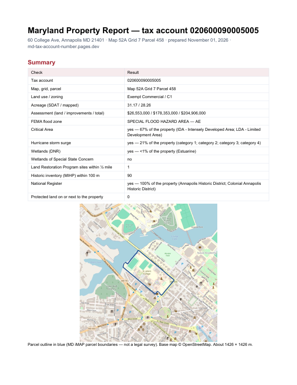
Before you buy in Charles County
The report adds what lies around one property: FEMA flood zone, Critical Area, wetlands, contaminated land sites nearby and historic properties.
$19card · PDF within 24 h · you pay after receiving itSee the sample (PDF)